|
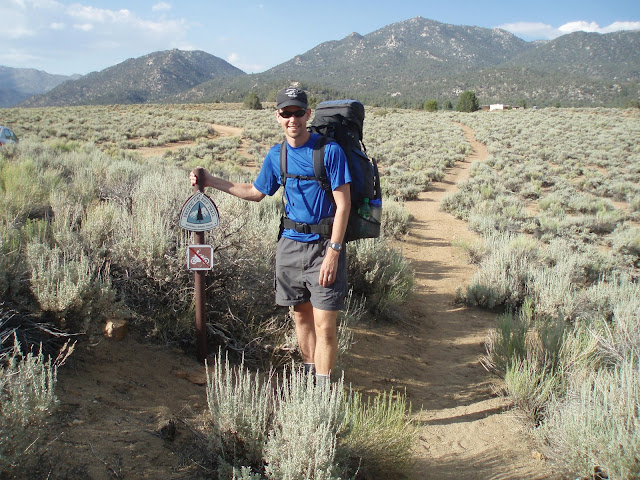
- Day 1: Kennedy Meadows Road to Kennedy
Meadows Campground
- 2.5 miles, no elevation gain
- Getting to the trailhead turned out to be quick complicated.
I flew from Washington to San Francisco, by way of Denver,
and stayed for a night at a hostel. I had some time in
the afternoon to explore
SF a bit, and went to the wharf area. In the morning
I took the SF subway to an Amtrak station, and from there south
to Bakersfield. I had made a contact with the Chamber of
Commerce in Kern, and someone volunteered to give me a ride to
the trail from there. She picked me up and we drove for
almost 2 hours into the mountains on winding gravel roads, finally
reaching Kennedy
Meadows Store. It took a little work to find the trail
where
it crossed the road near the store, and I
took off around 6:00 pm for the ~2 mile hike to the campground.
The campground was a typical
rustic Forest Service facility, and only a few sites were
taken. I set up my gear, and soon realized that the mosquitoes
were quite bad, so I ended up eating in my tent with the fly
off. Since it's mostly screen on top, I had a good view
this way, and I would end up following this pattern often throughout
the trip.
|
|
- Day 2: Kennedy Meadows Campground to Cow
Creek
- 15 miles, 3057 feet elevation gain | elevation
profile
- In the morning I slept in a bit in order to compensate for
the time change and being weary from travel. I was also
trying to be careful to avoid altitude problems. The campground
was at around 6000 feet, but I would be travelling much higher
over the next few days. The route was beautiful right from
the start. The first few miles were near a creek, passing
many large pine trees. I began to learn the names of common
pines and other conifers - Jeffery
Pine dominated the early miles. After a few miles I
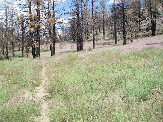
reached a section of forest that was burned
during an accidentally-set fire in the early 80s. The
sun was hot, and the route uphill, and soon I was struggling
to make progress. I took a break at the top of a hill,
and shortly afterward passed a group of backpackers who were
headed towards the campground. I would not see any other
hikers for 2 more days. I took a break in the afternoon
at the crossing of the Kern River, where many chimney swifts
had made nests under a bridge. Some "cowboys"
were there - they were guys from Bakersfield on a weekend trip
to the mountains, riding horses. They gave me some water.
As I watched the sky from the bank of the river, I noticed dark
clouds in the direction I was headed. As I pushed further north,
the sky began to rumble. I followed a small stream called
Cow Creek uphill, looking for a suitable campsite. I had
a hard time finding one, and ended up in a marginal site quite
close to the trail, almost on top of a clump of manzanita.
The rain did not materialize, and I enjoyed a quite night.
In the evening I scrambled up some nearby rocks while exploring,
and cut my toe on a rock. I was subsequently worried about
infection for several days, but thankfully nothing came of it.
|
|
- Day 3: Cow Creek to Corral at mile 737
- 17.4 miles, 3525 feet elevation gain | elevation
profile
- I slept in again, allowing for my body to further adjust
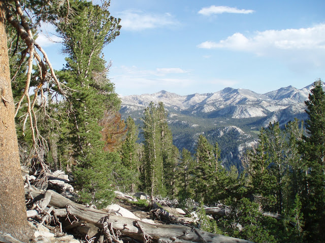
to the altitude. The trail was relatively easy, with a
moderately steep climb to start out followed by a ridge-top walk
with several views. The views
took in sparsely-forested mountains, with scattered grass and
sage-covered meadows. It was obviously a fairly dry
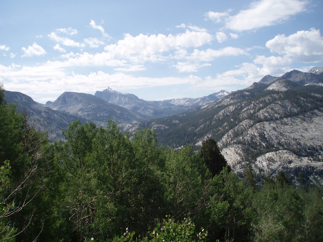
climate. Around mid-afternoon I took a break at Death Canyon
Creek and began a climb towards a high ridge - the highest point
on the trip so far. Near the top there was a view into
the Owens Valley, and I could see the mostly-dry Owens
Lake bed -- it's dry because the city of Los Angeles pipes
most of the water across the mountains. In his book, Cadillac
Desert, Mark Reiser explains how LA essentially stole the water
from the Owens Valley residents. I later met someone who
does air quality monitoring for the EPA in the Sierras, who indicated
that dust blowing from the lake valley puts the mountains out
of compliance with the Clean Air Act with regard to particulate
matter. There are even "dust
cams" on the web that monitor the situation with regularly-updated
images! It was an odd scene - I was high in the mountains, all
alone, staring down at this flat, open expanse. Clouds
soon started to gather again, and this time the storm came to
fruition - in the form of hail! Thankfully it only lasted
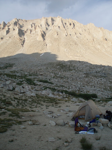
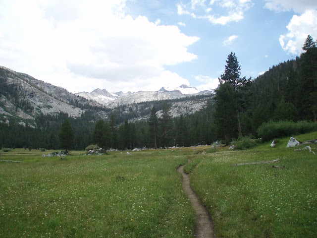
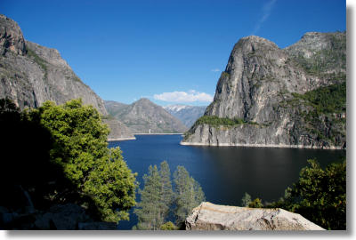
for a few minutes, and a couple of miles later I found a turnoff
to a meadow where I could camp (pictured here). You can
see the location
of the southern Sierras with respect to Owens Lake and Mt. Whitney
here - the first few days I was hiking between Kern Canyon
and Owens Valley (north is to the right on the photo)
|
|
- Day 4: Corral to brook near Rock Creek
- 21.8 miles, 1650 feet elevation gain
- The morning dawned clear and bright, as most mornings do
in the Sierra. I packed up and headed north along a relatively
easy stretch of trail. In the early afternoon I met a pair
of day-hikers - the first people I had in two days. They
were doing a loop from Cottonwood
Pass, where is there is a trailhead at the end of a long
gravel road. A few hours later, as I crossed a meadow,
a storm struck. It started as rain, but quickly moved to
hail, some of it quite large. I was unprepared, with my
glove and extra layers deep in my pack, so I had only my rain
coat for protection. The hail continued unabated for more
than an hour. Several times I stopped under a tree for
shelter, then pressed on when I was tired of waiting. I
crossed the outlet of a beautiful alpine lake called Chicken
Spring Lake, and continued to climb. By the time the
hail stopped, it had piled to at least three inches deep on the
trail. I soon passed a group of middle-aged women backpacking
in the other direction - they were headed for the lake.
I had considered camping at the lake, or near a spring a couple
of miles beyond - but I was so cold from the storm that I needed
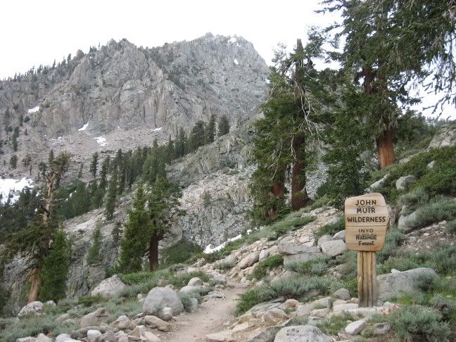
to keep hiking in order to warm up. I crossed the border
in Sequoia National
Park, and then began a long, gradual descent towards Rock
Creek. I found a campsite near a small stream, approximately
a mile from the larger Rock Creek.
|
|
- Day 5: Rock Creek to Guitar Lake
- 10.9 miles, 2150 feet elevation gain
- Since I ended up with a long hike the previous day, today
would be fairly short - I just needed to get to within striking
distance of Mt. Whitney. In the morning I ambled down to
my first major stream crossing at Rock Creek. I was able
to pick my way across on the rocks, using my poles for balance.
I saw a guy with NPS gear, carrying a baby on his back.
I found out he was married to the official backcountry ranger,
and they lived in a small cabin nearby. That would be quite
a life! The trail climbed steadily after the stream, crossing
open stands of pine. I passed a northbound hiker who told
me he had been on the trail since Walker Pass, 50 miles south
of where I started. There was virtually no water along
that stretch of trail during this point in the summer, and he
was dealing with major dehydration/electrolyte imbalance.
I took a nice break at the top of the pass, where there was a
view and some nice large rocks where I could spread out my gear
to dry. The next segment of trail was relatively
flat, with gravelly soil and scattered pines - an area known
as Guyot
Flat. I soon met an older gentleman who was wearing jeans
and carrying a suitcase - a very odd site in the mountains.
I met a ranger a few hours later who told me that this fellow
was homeless, and had climbed Trail Pass, close to Mt. Whitney,
from the Owens Valley. He was in search of gold - his only
hope, or so he thought. The ranger manned the district
closest to Mt. Whitney, and had been working in the park for
15 years - which meant that he knew Randy Morgenson. Ranger
Morgenson disappeared in the summer of 1996, after working in
the park's backcountry for more than 20 years; his story is told
in the book "The Last
Season". After passing the ranger
station, near Crabtree
Meadows, I struck out on a side trail. I had been following
the Pacific Crest Trail for these first 5 days, and now I was
joining the John Muir Trail, taking a detour to climb Mt. Whitney.
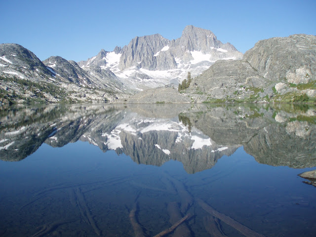
I passed a beautiful lake as a storm threatened, and then arrived
at Guitar Lake, where I found a spectacular setting for my campsite.
I spent the afternoon watching
the clouds, shadows, and light dance across the mountains
that soared above.
|
|
- Day 6: Mt. Whitney, then on to Bighorn
Flat
- 18.7 miles, 4243 feet elevation gain | elevation
profile
- This was quite a day. I arose before it was fully light,
and was still one of the last hikers to leave Guitar Lake in
heading for the top. I was already above treeline, and
after a mile or so began to climb steadily along a series of
switchbacks that seemed to go on forever. It was fun to
watch the bright
light begin to paint the tops of the mountains, then steadily
work
its way down.. I also enjoyed keeping track of the distant
spot near the lake
where my tent was still set up. At the top of the switchbacks
was an intersection - traveling one direction led to a crest,
and then the steep descent to Lone Pine in the Owens Valley.
Dozens, probably hundreds of hikers stream up from that trailhead
every summer day. I turned the other direction, to climb
the last 2 miles to the summit. The route dodged around
pinnacles of rock, between which there were spectacular views
to the east, and clamored over rocks. There was one stretch
of trail which was still
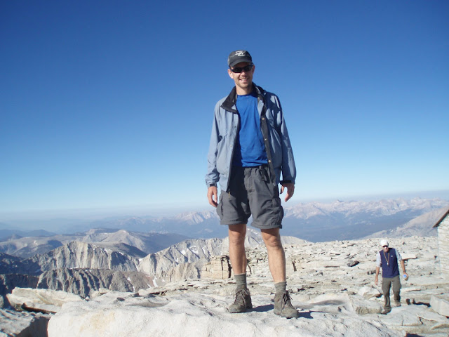
snow covered. When I finally reached
the top, a small group of hikers was gathered there - I had
passed a great number of people on the way up, my fast pace making
up for the later start. I spent over an our on top, taking
in the view and documenting with photos.
Then I made my way back down - there was still a long way to
go. When I reached my campsite, I packed everything back
up and took a short break to swim in the lake.
Jump into and right back out of the lake is more like it - it
was very cold! I took the side trail back towards the PCT,
and along the way I met the ranger I had seen the day before.
He was heading to the top of Whitney to help out with an astronomy
study. When I reached the PCT I continued north, passing
through relatively easy terrain. Towards late afternoon
I climbed to Bighorn Flat, where I came upon a small alpine tarn
in a stunning setting. I set up camp a few
feet from the water, and enjoyed the alpine
evening.
|
|
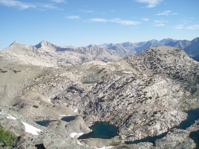
- Day 7: Bighorn Flat to Kearsarge Lakes
(over Forester Pass)
- 18.7 miles, 3546 feet elevation gain
- Today I would be climbing the highest pass on the PCT, so
I wanted to get an early start. Stormy weather often arises
late in the afternoon, so it's wise to hike in exposed areas
before noon whenever possible. In the morning there were
several stream crossings, including the first one that required
me to remove my shoes and ford across in sandals. For through-hikers,
who hike this section of trail during the June snow-melt, such
crossings are common, and can involve waist-high water.
I was glad for calmer July water levels. As the route approached
Forester Pass, it wound it's way above treeline for several
miles, through beautiful open country. I could
not tell where the pass was until I began the steep series
of switchbacks
. . the guidebooks related that the first scouts in this area
did
not recognize this pass as a navigable route! At the
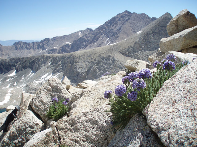
top there was a narrow
notch, and a terrific view
in both directions. I took a long break there, in what
would become a pattern for the tops of passes - might as well
get a reward for the hard work! There were several flowering
plants surviving in the extreme conditions, including the ones
pictured here. Beyond the pass, I descended across two
snowfields
that were still somewhat challenging. In one spot, my leg
went in up to my thigh, and I needed to dig my way out.
After many miles of slowly
descending through treeless country, I again reached a forested
section of trail along
Bubbs Creek. It was a beautiful
stretch of trail. In a few more miles, the trail climbed
again away from the creek, after reaching an intersection with
a trail headed west towards the developed part of the park.
After I steep climb I reached a side trail toward Kearsarge Pass.
Here I planned to hike out to Owens Valley, to the town of Independence,
to resupply my food. The side trail came high-recommended
by previous travelers, and not without reason - it followed the
edge of Bullfrog
Lake, with a spectacular
chain of jagged mountains behind. After three miles
I reached Kearsarge
Lakes, a cluster of small lakes huddled below Kearsarge Pass.
Other campers had taken the obvious campsites, but after some
searching I found a nice secluded
spot with a view.
|
|
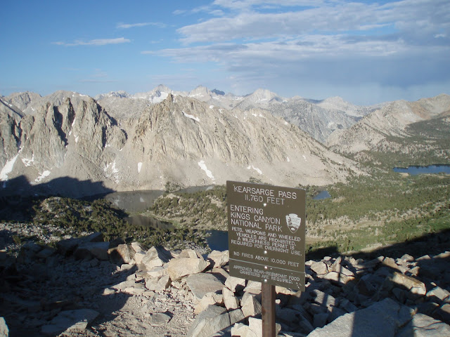
- Day 8: Kearsarge Lakes to Onion Valley,
then back over the pass to lake below Glen Pass
- 16 miles, 3360 feet elevation gain
- In the morning I pounded my way up to the top of the pass,
enjoying again beautiful
alpine scenery. The trail descended 3000 feet from
Kearsarge
Pass to the Onion Valley Trailhead. I passed several
day-hikers, and a handful
of scenic lakes, on the way down. Near the bottom the
route was quite
exposed, with switchbacks through a talus slope. When I reached
the parking
lot it was jammed full of cars, and I found another backpacker
trying to get a ride - it was the northbound hiker I had met
a few days earlier. He was having trouble staying on schedule,
and was planning to pick up more food so that he could make it
to his next food drop without running out. I only had to
wait a few minutes before someone offered me a ride down the
steep,
winding route to Independence. I picked up my food
from the post
office, then walked to a town
park to pack it. It was very hot in the valley - over
100 degrees. I called Tatiana from a pay phone and got
some lunch, then waited for a ride back to the
trailhead. Once again I did not have a long wait, and
soon was back in the parking lot. A brief, intense rain
shower passed by as I was getting ready to go again. On
the way back to the pass, I passed
many hikers. Onion Valley is one of the most popular
access points for the trail, because there is a paved road to
the trailhead and it only takes a few miles to reach the high
country. The other access points are all more challenging.
I dropped back from the pass to the PCT, then headed north for
a few miles, skirting above a popular camping area on Charlotte
Lake. I stopped to look for a campsite at a small,
un-named
lake just below Glen Pass. There was a small group
of campers near the lake, but I was able to find another spot
- a small,
flat gravel space surrounded by rock, with a view of the lake.
|
|
- Day 9: Glen Pass lake to Marjorie Lake
(over Pinchot Pass)
- 18 miles, 4173 feet elevation gain | elevation
profile
- I was ready for another long day when I got up the next morning. It
was a short, fairly easy climb up to the top
of the pass, with another outstanding view
in both directions. From there I descended 4000 feet, slowly
winding my way down to a bridge crossing at Woods Creek. After
the initial steep descent from Glen Pass I walzed through the
very scenic
and popular
Rae Lakes area. I encountered numerous hikers in this area.
It's possible to do a 40 mile loop from the frontcountry of Kings
Canyon to the west, and many hikers make this their destination.
Hikers from Onion Valley also head towards Rae
Lakes. One dramatic feature visible for several miles was
a granite dome called "Fin
Dome". Large Foxtail
Pines often flanked the trail. It was quite warm by the time
I reached Woods
Creek, and from there started a long, gradual ascent up another
4000 feet to Pinchot Pass. It was a steady climb and fairly taxing,
partly because the first few miles out
in the open and therefore were sunny and warm. The difficulty
was countered, however, by the fact that the trail followed an
impressive creek, which tumbled over numerous small waterfalls
and rapids. I went for a swim
in a lake near the trail around treeline. It was late in
the afternoon when I reached Pinchot Pass. After enjoying
the view, I continued a short distance down the other size
to a scenic lake basin and found a secluded
site near Marjorie Lake. As was typical for these high-apline
spots, it was sheltered
by large boulders and stunted Whitebark pines, and featured
spectacular views of steep granite mountains, upon which the
evening alpenglow played out.
|
|
- Day 10: Marjorie Lake to LeConte Canyon
(over Mather Pass, down Golden Staircase)
- 21.5 miles, 2710 feet elevation gain | elevation
profile
- I got an early start from Marjorie Lake, and headed downhill
towards the south fork of the Kings River. On the way I passed
a side trail to Bench
Lake, where a ranger is sometimes stationed. The crossing
of the Kings was a little tricky, and required changing into
sandals. I had a hard time shaking the mosquitoes for the next
couple of miles, and they would get worse during the next few
days. Upon reaching the pass, I continued into the next basin,
and soon descended to the supremely beautiful Palisade Lake basin.
There was another boots-off
crossing of a stream, and then the two Palisade Lakes. Lower
Palisade, in particular, was one of my favorites spots along
the entire trail - the lake was long
and narrow, occupying the bottom of a glacier-carved valley.
At the end of the lake, the land dropped off precititously, and
the trail followed numerous switchbacks along a route known as
the Golden
Staircase. This was the last section of the John Muir Trail
to be completed. At the bottom of the descent was an open forest,
part of which had been burned in the past decade. The descent
took more out of me than I realized, and after hiking through
sunny,
open forest for a few miles I was getting quite tired. I
eventually reached a junction at the middle fork of the Kings
River, two rivers came together, one of them with a dramatic
waterfall on it. On the other side lay a trail that leads back
west towards the Kings Canyon trailheads, but unfortunately the
bridge washed out a few years ago and there is no safe crossing.
The JMT was not affected by this, however; I turned upstream
and hiked for another mile or two until I reached the Bishop
Pass Trail, where several campsites were situated. I found a
good spot and stopped for the night. There were nice views high
peaks soaring above LeConte Canyon.
|
|
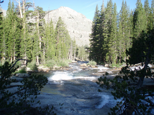
- Day 11: LeConte Canyon to McClure Meadow
(over Muir Pass and into Evolution Basin)
- 17 miles, 3260 feet elevation gain | elevation
profile
- I have found that no matter how tired I feel at the end of
a long day of backpacking, I always feel refreshed in the morning.
When dawn broke, I was ready to go again. The route up Leconte
Canyon was sometimes narrow, passing through forest and several
meadow areas. Soon I ascended to the alpine zone and began the
very
long climb to Muir Pass. Muir is the most exposed of all
the JMT passes, and was definately the most difficult climb.
There were several patches of snow on the approach, and the rock
type was different, which made the going more difficult. At times
it was hard to see where the trail went next. Towards the top
was Helen
Lake, but it was hard to know for sure when I reached it
because there were several lakes in succession, each around the
bend (and up) from each other. Eventually I did reach the top,
where a circular
stone shelter guards a low saddle - it had a very different
feel from the narrow tops of the typical passes. Several other
hikers were there taking a break. I took a long break as well,
and eventually pressed on. The descent was fairly easy at first,
and the next
few miles I passed through the largely treeless Evolution
Basin. Along the edge of Wanda
Lake I saw several yellow-legged
frogs - a threatened
species whose numbers have been reduced by introduced, non-native
trout in much of its orginal range. They survive here, in the
wilderness, out of the reach of the fish. I passed several
large lakes in this apline zone, all surrounded by steep
mountains and alpine meadows. After a steep descent - the Evolution
Basin is a "hanging
valley", where one glacier was cut off from a faster-eroding,
lower one - I reached Evolution Valley. I found an excellent
campsite on the edge of McClure Meadow, arriving just as
a brief afternoon rain shower settled in. After the rain, the
sun returned in the evening and I enjoyed strolling
along the river and and capturing
the alpenglow on the mountains.
|
|
- Day 12: McClure Meadow to Marie Lake
(over Seldon Pass)
- 18.5 miles, 3290 feet elevation gain | elevation
profile
- Morning arrived in typical beautiful fashion for the Sierras,
and it was time to head further north. McClure
Meadow is one place where ranger Randy Morgensen had spent
many summers, and I thought about that often as I hiked along
the edge of the meadow. According the The Last Season,
Morgensen had advocated for tighter restrictions on grazing of
horses in this an other sensitive sub-apline meadows. Later that
morning, I saw evidence that his fight was not in vain - a posted
sign noted grazing restrictions, and I
had to pass through a gate. It was one of many such gates
that I encountered during the hike. Travellers in these mountains
use horses both for personal travel, and to carry large loads
of gear. One afternoon on the way toward Mather Pass, I saw a
packer walking, leading a chain of 6 horses tied together. Each
of them was laden with cargo of some type - one looked to be
carrying a guitar! I am not sure where they were headed. Near
the lower end of the Evolution Valley I had to cross Evolution
Creek, which was the most challenging crossing of the trip.
The mosquitoes where ferouscious, which made it difficult to
stop and change my shoes. The river was wider (at least 100 yards)
and deeper (mid-thigh) than any other I had encountered. After
the crossing, the trail followed
the creek for a while and then descended steeply again out
of Evolution Valley, which is also a hanging valley. At the bottom
was the San
Jaoquin River, which was crossed by a sturdy
bridge. The trail then followed the river downstream for
many
scenic miles. Rapids
and small waterfalls punctuated the canyon-carving
river. At length I reached the intersection with another
stream, which marked the northern
border of Kings Canyon National Park. Upon crossing the creek,
on another bridge, I entered
the John Muir Wilderness. After a few more miles, I took
a side trail to Muir
Trail Ranch. This remote
resort serves horseback riders and fishermen, and is also
a major repupply post for hikers. From the outside world, it
is usually reached on horseback, and that is how supplies are
brought in. I was nearly out of insect repellent, so I bought
some at the store, and refilled my water. My filter had broken
2 days earlier, and I was trying to reduce the need to use my
backup tablets for treatment. From the ranch, I followed a steep
trail further north, aiming to cross Selden Pass later that afternoon.
The climb eased into switchbacks
along an open slope covered with manzanita, which seemed
to go on forever. The climb continued through forest, and eventually
the trail reached a cluster
of lakes near the top of the pass. I had initially thought
to camp here, but it was still mid-afternoon so I pressed on.
I passed several people who were part of an SCA trail crew, doing
volunteer maintenance. At the top
of Selden Pass I took the obligatory break, and then continued
a short distance to the lake
basin immediately below the pass, where I found a somewhat-exposed
site here Marie Lake. It rained for about an hour after I
set up camp, but as usual the weather
cleared in the evening and the sunset played across the granite.
|
|
- Day 13: Marie Lake to Vermilion Valley
Resort/Edison Lake
- 14.4 miles, 1110 feet elevation gain | elevation
profile
- Today involved a fairly easy route to Vermillion
Valley Resort, where I planned to re-supply for my final
segment. The trail dropped gradually from Selden Pass towards
a low point, then climbed
over a ridge before descending a steep series of switchbacks
through mature firs and pines. Near the bottom the trail flattened
out and passed through a rare
stand of deciduous trees - aspens. At the bottom was a bridge
across Mono Creek, followed by a side trail to the ferry landing
at Edison
Lake. The resort is on the other side, and operates a twice-daily
ferry. I arrived in the early afternoon, and considered following
a trail around the lake instead of waiting three hours for the
boat, but after settling in and meeting some of the others who
were waiting, I deciding to forgo the extra mileage - on what
was purported to be a poorly-maintained trail through sunny,
open country. When the ferry
finally arrived, there were so many hikers waiting that they
had to make some people what for a second trip. Thankfully, I
made
it on the first round. Upon arrival at the resort,
which caters to fishermen as well as hikers (and is accessible
via a rough road from the west), I set up my tent in a grove
of trees, started some laundry, and had dinner in the restaurant.
|
|
- Day 14: VVR to Duck Pass Creek (over
Silver Pass)
- 18.8 miles, 4243 feet elevation gain | elevation
profile
- In the morning I planned to have breakfast at the restuarant
before returning on the ferry to the trail. Things got a little
tense because the kitchen was behind on orders, and I almost
did not have time to finish my breakfast before the boat left.
The route turned out to be one of the most challenging of the
entire trip. Edison Lake is one of the lowest spots on the entire
JMT, and I was bound for 11,000-foot Silver Pass. The intitial
route was along Mono Creek, and eventually the trail climbed
steeply towards
the pass. A storm was threatening when I reached the
top, but it still appeared a ways off so I took a short break.
When I began to descend, the wind was picking up and the clouds
getting darker, and I was glad to be on the way down - especially
when I encountered some hikers headed the other way. Not much
rain materialized, but these storms are so localized that it
may well have been more severe at the top of the pass. After
descending to a meadow/valley known as Tully
Hole, I faced another steep series of switchbacks, before
reaching Lake
Virginia around 4:00. The sky had grown cloudy again, and
the wind made it feel quite cold. A number of campers were already
selecting sites around the lake, but I opted to continue for
a couple more miles. Remarkable, the weather soon cleared and
I found myself in bright sunshine again. I continued pass Purple
Lake as well, and pressed for a stream crossing where I knew
I could find a campsite. The trail followed a ridge with a terrific
view to the west of a parallel
chain of jagged mountains. After a couple of miles I reached
a small creek near the intersection with a trail over Duck Pass.
I found a nice
site near the water and enjoyed a relaxing evening.
|
|
- Day 15: Duck Creek Pass to Ediza Junction
(through Reds Meadow and Devils Postpile)
- 22.6 miles, 2300 feet elevation gain | elevation
profile
- Today's hike was split into two segments, with a mid-day
break at Red's Meadow. I zipped along for the first 10 miles,
which were mostly downhill. The first 5 miles featured similar
views to those I had been wowed by yesterday afternoon. After
crossing a creek, the trail descended a steep series of switchbacks
as it headed for Reds Meadow. On the way down, I caught glimpses
of a cinder
cone, the remains of ancient volcanic activity. At the bottom
of the descent was a burned-over
area that was subject to wildfire
in 1992. I soon began to see trickles of tourists in shorts
and flip-flops - an odd site along the JMT, which is mostly inaccessible
even to serious day-hikers because of its remote location. Here,
the trail pass very close to Red's
Meadow, a privately-operated rustic
resort located within the National Forest and adjacent to
Devils Postpile National
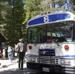
Monument. Tourists can take a shuttle
bus from nearby Mammoth, a large ski resort that also host
year-round crowds. I followed a side trail to the resort, where
I got a burger for lunch and called Tatiana. Then I returned
to the trail, and took another side trip through the National
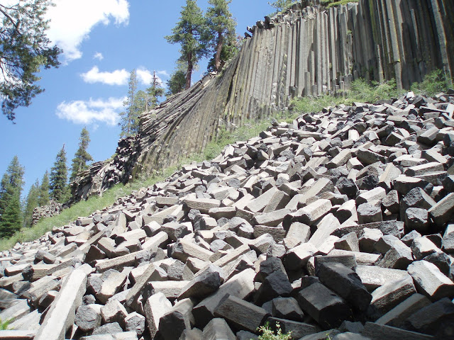
Monument. Devil's Postpile is a volcanic rock formation, consisting
of large 6-sided
columns of igneous rock that cooled under just the right
conditions to form perfect columns. The formation was exposed
by glacial activity during the most recent ice age. After hiking
the short interpretive trail I made a quick stop at the park
visitor center, then hurried back to the main route. Shortly,
I came to the only spot along its route where the JMT follows
a different route from the PCT (which the execption of the two
ends of the trail). Each trail follows one of two ridges that
flank a long valley. The JMT was reported to be more scenic as
well as more rugged, so I stayed on the JMT. The route turned
out to be challenging, but not in the way I expected - the mosquitoes
were out in full force. Even continuous hiking was not enough
to keep them away in some stretches. The route climbed fairly
steadily, passing a few lakes on the way to a high point at a
Shadow
Lake, where camping is not allowed. In spite of this prohibition,
I saw several tents. I continued beyond the restricted zone and
found a legal
campsite, again with view of soaring peaks that reflected
evening light.
|
|
- Day 16: Ediza Junction to Lyell Canyon
(over Donohue Pass and into Yosemite)
- 18.2 miles, 3115 feet elevation gain | elevation
profile
- I woke to another glorious morning, and began and up and
down day. There were some excellent
views from the initial climb. By mid-morning I reached Garnet
Lake. The reflection
of snow-capped mountains onto the clear-blue water provided
a great backdrop for a whole batch of pictures. It was worth
taking the JMT through this section, as opposed to the parallel
PCT, just to get these views. After another 2 miles I reached
the equally-scenic Thousand
Island Lake, where the PCT rejoined the route. Quite a few
day-hikers and short-trip backpackers were around, which was
a change from what I had experienced earlier - for the first
2 weeks of the trip almost all of the other hikers I encountered
were southbound on the JMT and were out for a least a week -
2 or 3 if doing the entire route. Beyond the lake the trail climbed
irregularly to the indistict top of Island
Lake Pass, then dropped to a low spot before a more serious
climb to Donohue
Pass, at the border with Yosemite
National Park. I took my traditional break at this pass -
the last
alpine zone for the trip. The next few miles were a long
descent to the bottom of Lyell
Canyon, a nearly-flat valley covered with meadows that runs
all the way to Tuolomne. The route first passed a pretty
little alpine lake, then crossed a creek and plunged downhill,
eventually into deep forest. In one spot a waterfall
spilled onto the trail. Eventually it flattened out to follow
the meadow-filled
canyon. I camped along the edge of the meadow after following
it for a few miles.
|
|
- Day 17: Lyell Canyon to Clouds Rest Junction
- 23 miles, 2065 feet elevation gain
- In the morning I cruised along the flat
canyon bottom to Tuolomne Meadows, one of the busiest places
in Yosemite. Tuolomne has a large campground, visitor center,
and other services, and is a major trailhead for backcountry
trips. The Tuolomne
River, a fork of which I had been following in Lyell Canyon,
flows through the area, then descends through a dramatic canyon
to the Hetch
Hetchy Valley, which was filled with a reservoir in the early
1900s to provide water for SanFransico. John Muir opposed construction
of the dam, but did not prevail in his efforts to stop it. I
wandered around the area for a bit without my pack, and called
Tatiana from a pay phone. Then I pushed on, taking the route
of the JMT towards Yosemite Valley, now separate from the PCT,
which continues north into the Yosemite backcountry. The trail
was well-used here, and the tread was ground to a fine dust in
places, which made it somewhat uncomfortable to walk on. I saw
several dramatic
granite features rising from the forests. Many of these landforms
were carved in distinctive ways by glaciers, and it was here
that some of the first principles of mountain glaciation were
studied and understood. I saw some climbers who were drawn by
the iconic rock faces, as well as a number of day-hikers. The
route climbed over one
last pass - Cathedral Pass - although this one did not rise
above tree line. The route varied between forests
of pine and meadows
dotted with lakes. Around mid-afternoon I crossed a large
meadow and stopped at Sunrise, one of the High
Sierra Camps. These are backcountry lodges that provide sleeping
accomodations in canvas tents, as well as hot meals in a common
area. A handful of them are scattered about the park, arranged
such that groups can hike from one to the next for a few days.
Beyond Sunrise, the trail began to descend
steadily, and as light waned I found a campsite
with a view
of the back side of Half Dome. I was a bit nervous about
camping in this area, because the bears have a reputation for
causing trouble. The previous day, a bear had torn apart someone's
pack in spite of the fact that their food was properly stored
in a canister, as mine was. As darkness fell, I heard nearby
campers yelling at a bear to scare it away, but I did not have
any trouble and managed to get some sleep.
|
|
- Day 18: climb half dome, then descend
to Yosemite Valley
- 10 miles, ~1900 feet elevation gain
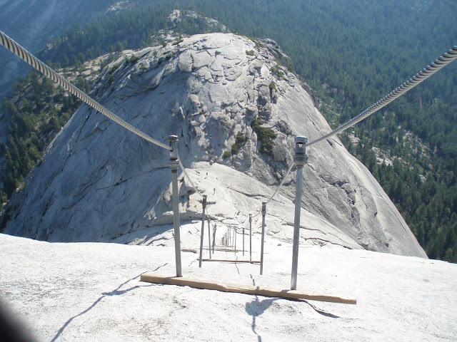
- I woke early so that I could climb Half Dome, the famous
rock that towers over Yosemite Valley. I left my pack near the
intersection with the side trail to the dome, and cruised up
the steep trail towards the rock. Upon reaching the rocky part
of the mountain, the trail first ascended a steep section of
mountain with steps
cut into the rock at various points. After climbing this
section the trail leveled off briefly and crossed a saddle before
ascending
the famous cables. Here the rock face is so steep that the
only way to safely climb is with the assistance of a metal
cable that is bolted to the rock. It took some time to ascend,
because I had to wait for several people who had climbed before
sunrise, who were now coming back down. I was also behind a guided
group that included some slower hikers. Upon reaching
the top, I took some time to survey
the scene - a terrific 360 degree view, including a panorama
of the famous
Yosemite Valley. The return
down the cables was a
bit scary, but not too bad. Eventually I returned to my pack,
and was relieved to find that no bears had plundered it. The
rest
of the JMT was increasingly crowded with day hikers as I
descended. In the past few miles I passed two famous waterfalls,
Vernal
Fall and Nevada
Falls. In the last mile the crowds were almost overwhelming.
When I reached
the valley I spent several hours exploring, getting views
of Half Dome and Yosemite Falls, and touring the visitor center.
|