 Day Hikes and weekend
backpacking trips: Roanoke, Virginia to Harriman State Park, New York
Day Hikes and weekend
backpacking trips: Roanoke, Virginia to Harriman State Park, New York
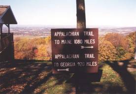
My first AT day hike was from the Pennsylvania section that includes Lehigh
Gap, on a hike with the Wilmington Trail Club, around 1997 or 98. I finished the final day-hike section in the
fall of 2006. These short hikes covered
the entire trail between Harriman State Park in New York
and Montvale Overlook on the Blue
Ridge Parkway, a few miles north of Roanoke. Here I describe the hikes in geographic
order, starting from the south:
10/7/06 Long Mnt. Wayside à James
River 21.4 Elevation
profile
10/8/06 BRP mp73 à Montvale Overlook 26.3 Elevation
profile
10/9/06 BRP mp 73 à James
River 14.9 Elevation
profile
Detail map of this section | and
the section between the James River and
Shenandoah
In autumn of 2006 Tatiana and I camped for the weekend at Peaks of Otter, along the Blue Ridge Parkway. Peaks of Otter has been a favorite place for
me ever since I stayed there during one of my first solo spring break
trips. We drove down with our camping
equipment on Friday after work. The
weather was rather uninviting – cold and rainy.
We had invited some friends to join us, and we were glad nobody had been
able to come because the weather was not nice for hanging out around the
campsite. The next morning it was still
cool and rainy, with lots of fog around.
We drove north up the Parkway to US 60 and accessed the trail at Long
Mountain Wayside, which is a small picnic/parking area. I started hiking south. The trail here is a bit unusual – normally
road crossings are at a local low point on the trail, and hiking from a road
means an immediate climb. 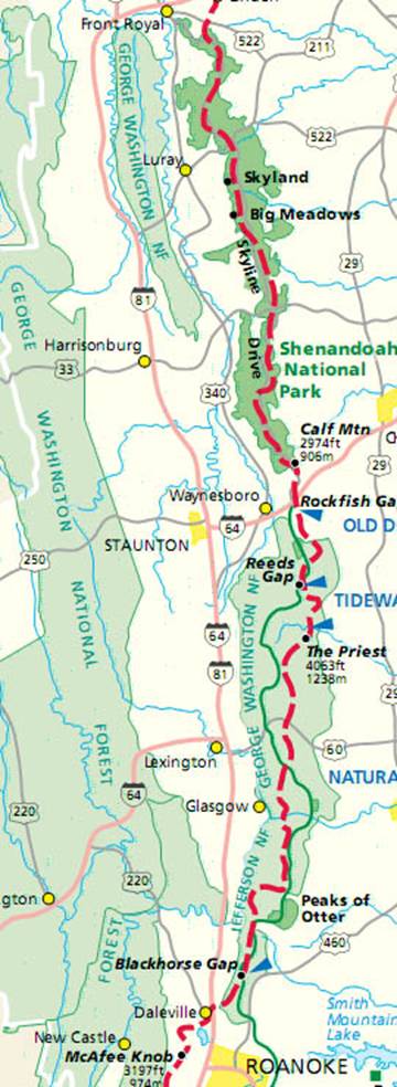 Here
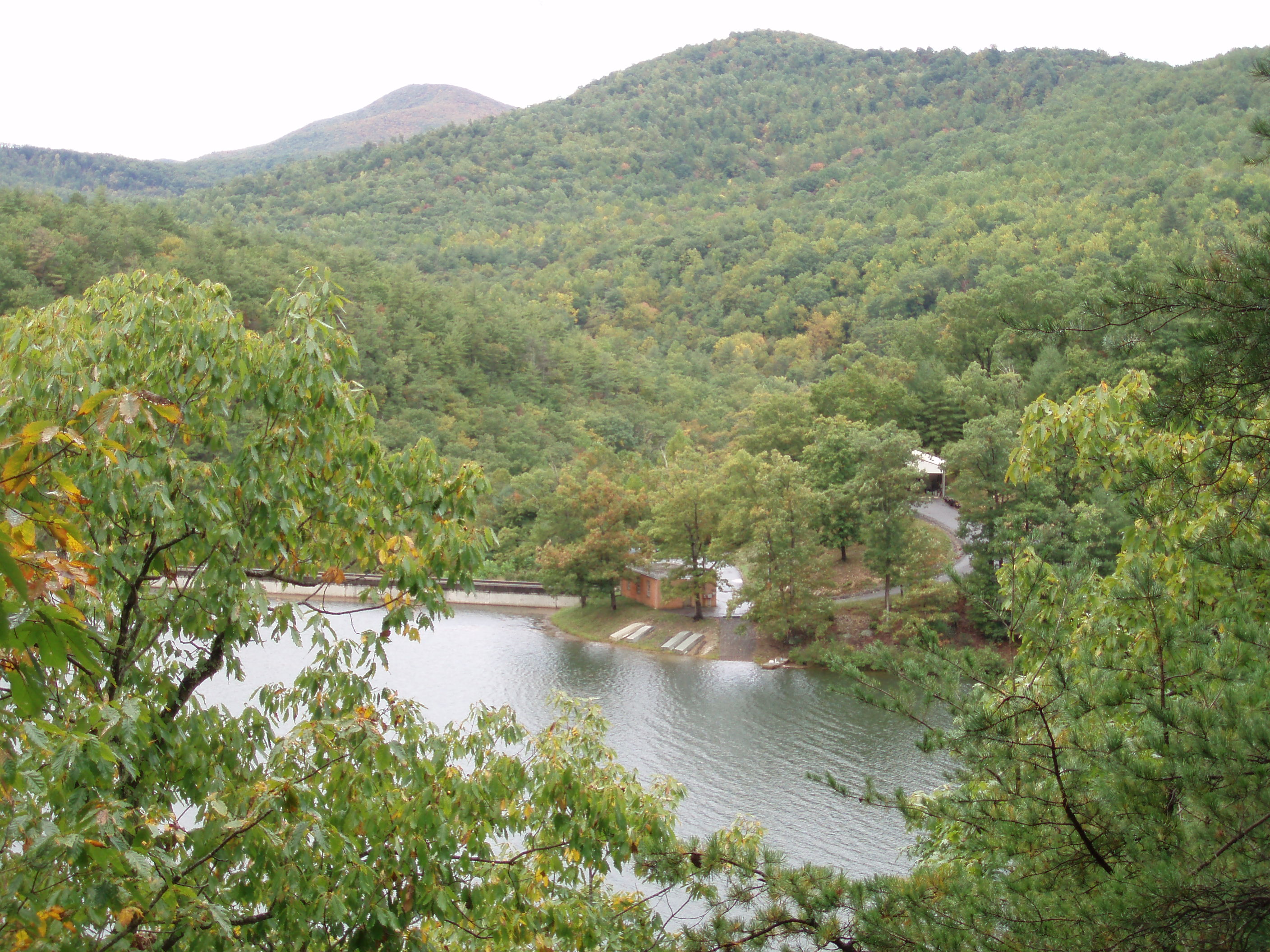
the trail actually descends as you hike south from the road. The trail eventually passes the Pedlar
dam and reservoir. The reservoir is
interesting because it is completely surrounded by trees, feels like its “in
the middle of nowhere”, and its shoreline is not marked by vacation homes or
recreational facilities. The trail
crosses a relatively
new footbridge below the reservoir.
The trail later climbed to a viewpoint
at an old
fire tower on Bluff Mountain, and a memorial to a young child who wandered into
the woods and was lost. The weather
cleared just a bit when I paused at the top, but rain and clouds still
predominated as I met Tatiana (who was coming from the other direction) and
descended toward the James River.
Here
the trail actually descends as you hike south from the road. The trail eventually passes the Pedlar
dam and reservoir. The reservoir is
interesting because it is completely surrounded by trees, feels like its “in
the middle of nowhere”, and its shoreline is not marked by vacation homes or
recreational facilities. The trail
crosses a relatively
new footbridge below the reservoir.
The trail later climbed to a viewpoint
at an old
fire tower on Bluff Mountain, and a memorial to a young child who wandered into
the woods and was lost. The weather
cleared just a bit when I paused at the top, but rain and clouds still
predominated as I met Tatiana (who was coming from the other direction) and
descended toward the James River.
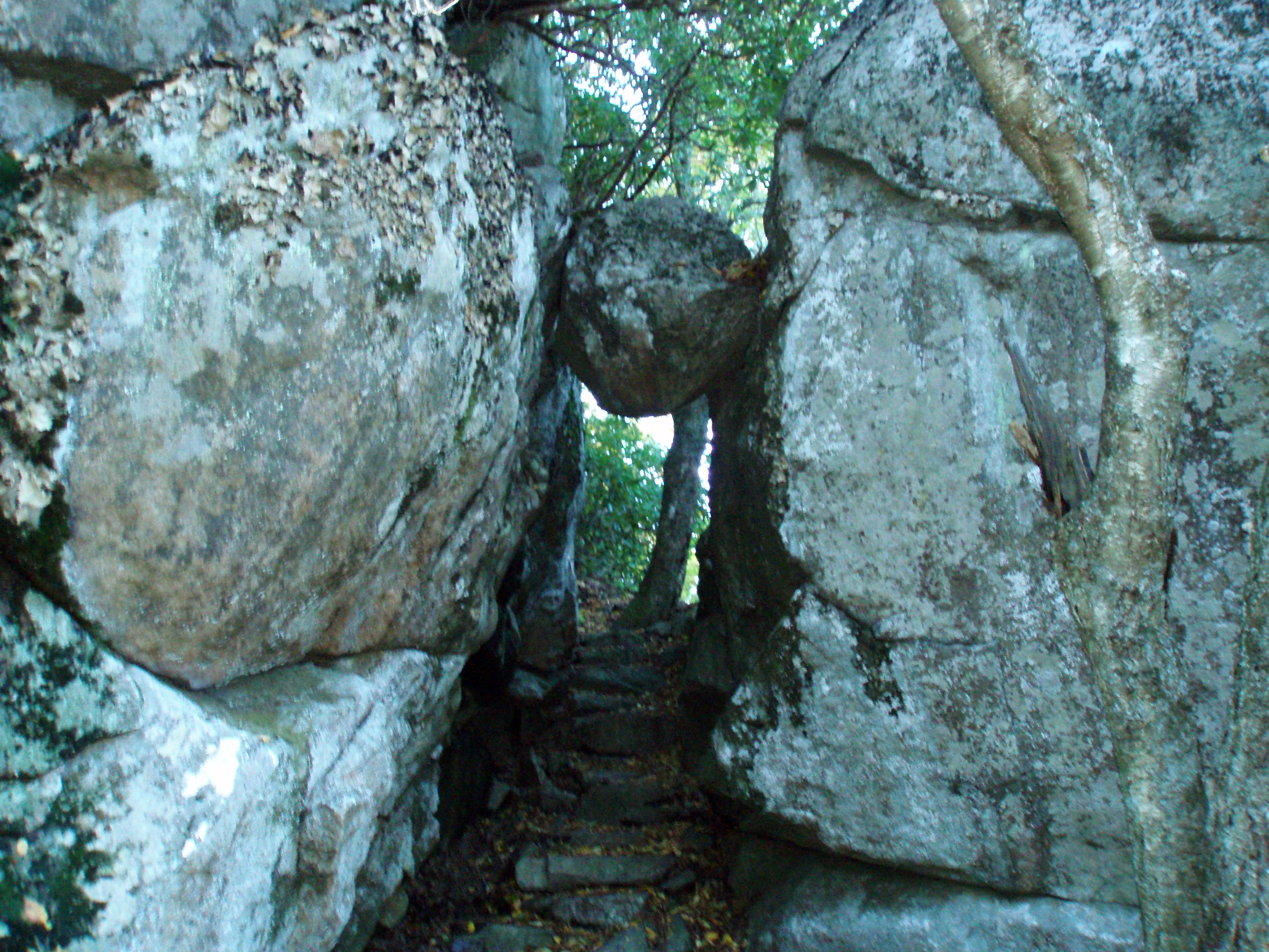
The following day I started hiking south at Blue Ridge
Parkway mile marker 73, which is maybe 10 miles north of Peaks of Otter. This section immediately passes a couple of
interesting spots. First was a rock
formation called the
guillotine, where the trail passes beneath a large rock that is wedged
between other rocks. A short time later
I reached Apple
Orchard Mountain, which at 4225’ is one of the highest points in the region
– in fact, I think the trail does not reach that elevation again in the
northbound direction until Vermont. The
summit is grassy, and houses a fenced military compound, which consists of an
array of un-manned antennas and similar equipment. The peak was surrounded by fog, obscuring
what promised to otherwise be a great view.
From there, the trail descended a long way as it pulled away from its
course paralleling the Parkway. I passed
a new shelter at Bryant
Ridge. The shelter has space for 20 people, and has
a loft and covered cooking area. Soon
afterward I began to climb again, eventually re-gaining the ridge and crossing
the Parkway. In the afternoon the
weather began to clear, and we were able to admire the Shenandoah
Valley at several viewpoints.
Along the way we also bumped into a southbound through-hiker named
Kingfish. I had met Kingfish in Maine earlier that
summer, and he remembered me. It took me
a few minutes to recall the meeting, but then I remembered stopping at a
shelter around mid-day after climbing Saddleback Mountain. Kingfish was one of a half dozen south
bounders hanging out in the shelter.
When we talked to him today he shared that he hoped to finish the trail
before Thanksgiving. When I was at
Elmer’s in Hot Springs
the following spring, I saw on the wall a card from Kingfish, indicating he had
indeed finished the trail in mid-November.
 On
Columbus Day we awoke to
On
Columbus Day we awoke to 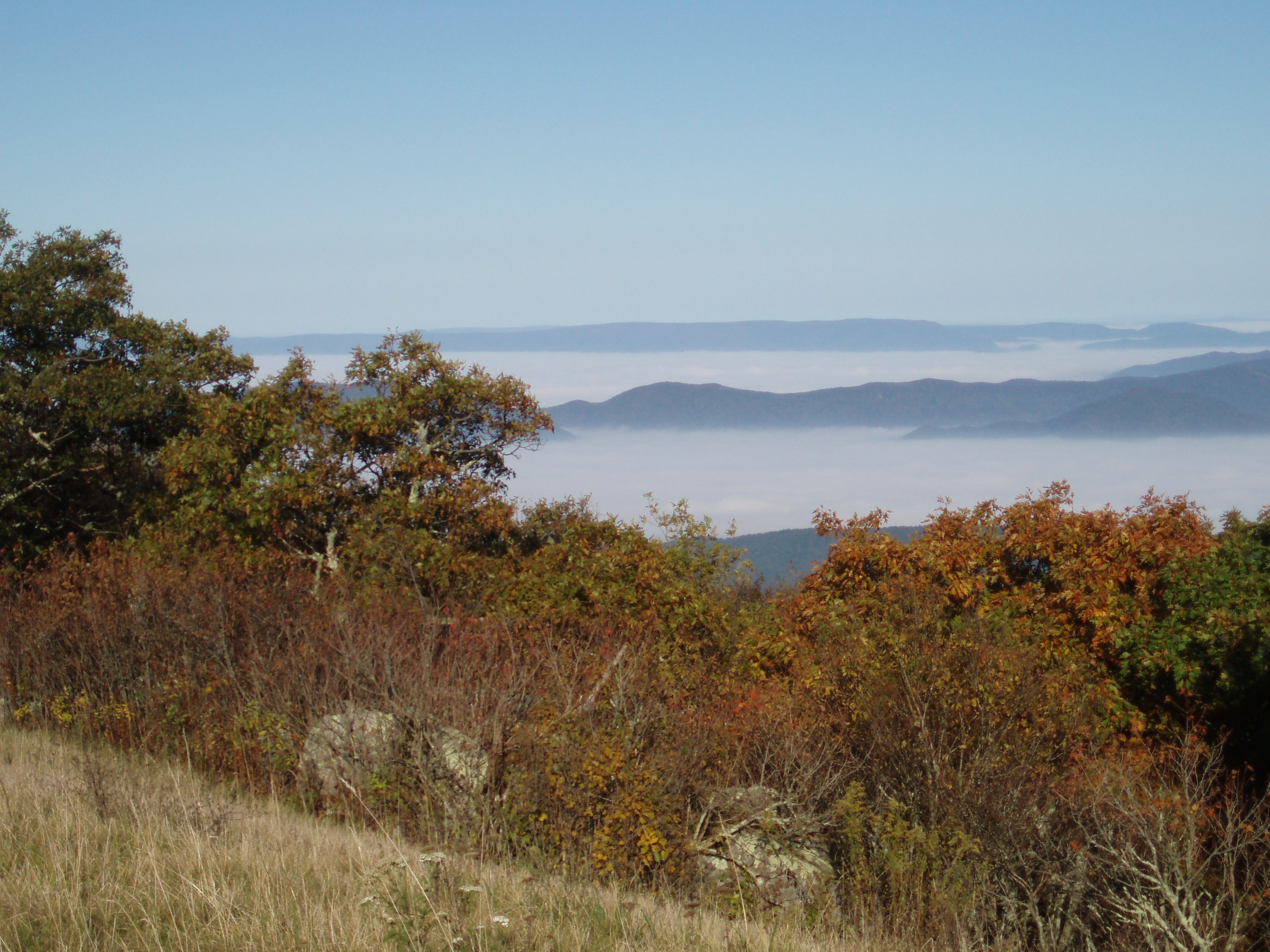 beautiful fall weather and broke
camp. I started hiking again at Parkway
milepost 73. Since the weather was
better, I hiked south again for a mile to the top of Apple Orchard
Mountain, and this time
was treated to amazing views of the valley.
The skies were clear blue, but the valley below was filled with white,
snaking clouds. A very cool effect. After checking out the view I turned around
and hiked north, eventually meeting Tatiana.
She turned around and we headed downhill
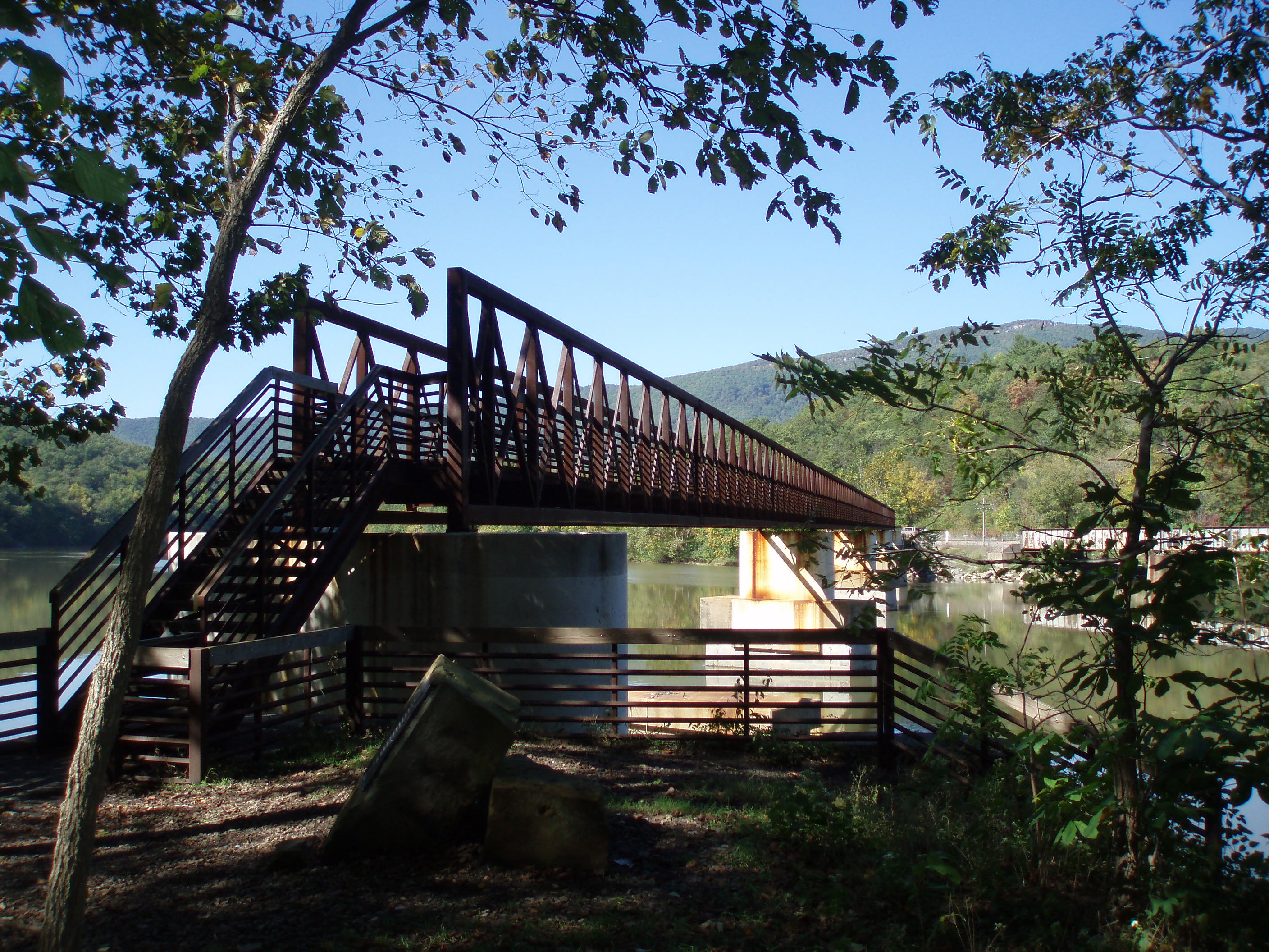
to the James River. Near the bottom
of the descent we passed the Matts
Creek Shelter, where a trail crew had just finished replacing a washed-out bridge
with a sort of engineered crossing point for a small stream. The James River
is one of the widest rivers crossed by the trail, and the crossing is
accomplished via a recently constructed bridge.
The bridge is the longest dedicated pedestrian bridge on the trail. The trail crosses most large rivers by using
an auto bridge, or in the case of the Potomac,
a railroad bridge. It was fun to use
this bridge to finish the hike.
beautiful fall weather and broke
camp. I started hiking again at Parkway
milepost 73. Since the weather was
better, I hiked south again for a mile to the top of Apple Orchard
Mountain, and this time
was treated to amazing views of the valley.
The skies were clear blue, but the valley below was filled with white,
snaking clouds. A very cool effect. After checking out the view I turned around
and hiked north, eventually meeting Tatiana.
She turned around and we headed downhill
to the James River. Near the bottom
of the descent we passed the Matts
Creek Shelter, where a trail crew had just finished replacing a washed-out bridge
with a sort of engineered crossing point for a small stream. The James River
is one of the widest rivers crossed by the trail, and the crossing is
accomplished via a recently constructed bridge.
The bridge is the longest dedicated pedestrian bridge on the trail. The trail crosses most large rivers by using
an auto bridge, or in the case of the Potomac,
a railroad bridge. It was fun to use
this bridge to finish the hike.
5/13/06 Tye
River à Long
Mountain wayside 25.7 Elevation
profile
We hiked this section of the trail in May of 2006. Because we had missed church several Sundays
for Spring Break and other reasons, and were planning to be away much of the
summer, we decided to hike one day and then return home. We drove down on Friday after work, and
camped in the private Crabtree
Falls Campground near the trail along Virginia route 56. It was a nice small campground in a wooded
area along the Tye
River, and we had a
walk-in site that was tucked away near the river. In the morning we checked out the Crabtree Falls, which are
on Forest Service land, before starting the hike. The trail in this section drops away from the
high ridgeline along the Parkway to an elevation below 1000 feet at the Tye River,
before immediately climbing again to regain the ridge – which makes this a
fairly strenuous section to hike. The
immediate goal heading southbound is a mountain known as the Priest (which
can be seen here, as viewed from the north across the river valley), which
at 4063 feet is one of the higher spots in this section of the Blue Ridge. The climb was indeed long, but with a daypack
I handled it without much difficultly.
The summit is wooded, but there were a couple of viewpoints along the
trail. A few miles later I encountered a
more prominent viewpoint known as Spy
Rock. Here a large rock outcropping
rises above the trees to provide a view
of the surrounding area. My
brother-in-law Tyson told me that he met famous through-hiker Earl Schaeffer
here back in 1998. Earl was hiking the
trail at age 79, on the 50th anniversary of his first through-hike,
which is the first documented hike of the entire trail in one season. Further south, after meeting up with Tatiana,
we crossed a beautiful
grassy ridgeline known as Bald Knob.
The descent to US 60 at Long Mountain Wayside involved more than 10
switchbacks, which were (oddly) marked with painted numbers on the trees.
5/7/05 Tye River
à
Rockfish Gap 29.9 Elevation
profile
In May 2005 we decided to camp and hike for the weekend
along the Blue Ridge Parkway south of
Shenandoah. We drove down after work on
Friday, and camped at Sherando
Lake, which is one of the largest Forest Service campgrounds I have ever
been in. There are several loops with wooded
sites and CCC era construction, bathroom buildings with running water and
showers. The campground was quite busy,
because there was a triathlon scheduled to take place in the area that weekend,
using the swimming area at the campground for the water portion of the
contest. On Saturday morning Tatiana
dropped me off on Virginia
56, where the trail crosses the Tye
River on a nice
long bridge at an elevation below 1000 feet. From this point the trail climbs
significantly to re-gain the ridge and parallel the Blue Ridge Parkway. The climb was challenging, and I was feeling
a bit impaired by a cold. I eventually met up with Tatiana at Humpback
Rocks, which is a popular viewpoint accessible from a side trail to the Blue Ridge Parkway. We continued north through a heavily-wooded
section of trail that seemed to stretch on forever. In late afternoon we took a break at the Paul
Wolfe Shelter, and I realized I was nearly out of water. By this time the weather was quite warm, and
the knowledge that I was hiking without water made me feel uncomfortable. I passed on the opportunity to take a short
side-trail to a viewpoint, which 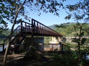 is unusual for me – I just felt too
tired. As we got closer to the car,
clouds and thunder began to build, and we found ourselves walking in a downpour
for the last mile or so. The rain
drenched us, but it was nice to cool off a bit.
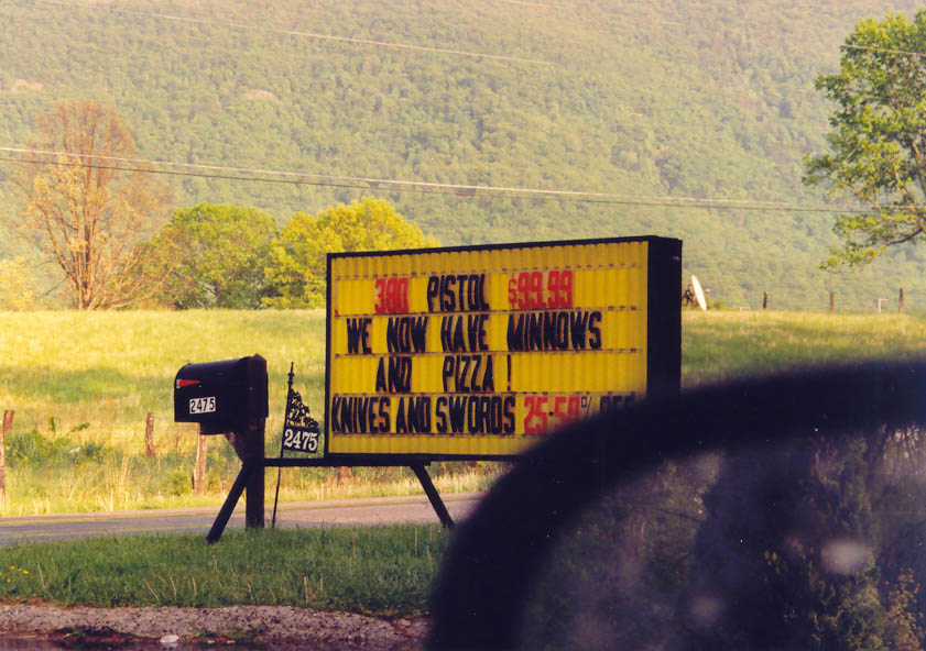
On the way back to the campground we stopped at a convenience store that
was advertising an unusual array of goods, including guns and swords (see the
picture). Upon returning to the
campground we took a closer look at our trail guides. We had planned the hike using the map and a
guidebook published in the 90s, which listed the distance as 25 miles. A long hike, but not beyond my ability. Upon taking a closer look at my 2005 copy of
the Thru-hikers Handbook, I realized that the segment north of Humpback Rocks
had undergone a significant relocation in the previous year, resulting in an
extra 5 miles being added to the trail.
No wonder I ran out of water and felt wiped out! After hiking that far, and dealing with extra
energy drain from being sick, we decided that our plan of hiking another long
section, including a 3000’ climb of the Priest, should be deferred. The next morning we stopped at the exhibition
about Appalachian farm life along the Parkway near Humpback Rocks, and then slowly
made our way home. We eventually hiked
that next section a year later, in the hike described above.
is unusual for me – I just felt too
tired. As we got closer to the car,
clouds and thunder began to build, and we found ourselves walking in a downpour
for the last mile or so. The rain
drenched us, but it was nice to cool off a bit.
On the way back to the campground we stopped at a convenience store that
was advertising an unusual array of goods, including guns and swords (see the
picture). Upon returning to the
campground we took a closer look at our trail guides. We had planned the hike using the map and a
guidebook published in the 90s, which listed the distance as 25 miles. A long hike, but not beyond my ability. Upon taking a closer look at my 2005 copy of
the Thru-hikers Handbook, I realized that the segment north of Humpback Rocks
had undergone a significant relocation in the previous year, resulting in an
extra 5 miles being added to the trail.
No wonder I ran out of water and felt wiped out! After hiking that far, and dealing with extra
energy drain from being sick, we decided that our plan of hiking another long
section, including a 3000’ climb of the Priest, should be deferred. The next morning we stopped at the exhibition
about Appalachian farm life along the Parkway near Humpback Rocks, and then slowly
made our way home. We eventually hiked
that next section a year later, in the hike described above.
Approximately 100 miles of the Appalachian Trail runs parallel
to Skyline Drive within Shenandoah
National Park. We have spent quite a
lot of time there over the years. I
think my first hike along any section of the AT might have been in
Shenandoah. We camped at Big Meadows in
1985, when I was 12 years old, and did some hiking that included short sections
of the AT. Describing how I have covered
the AT within the park gets a little complicated, because there have been so
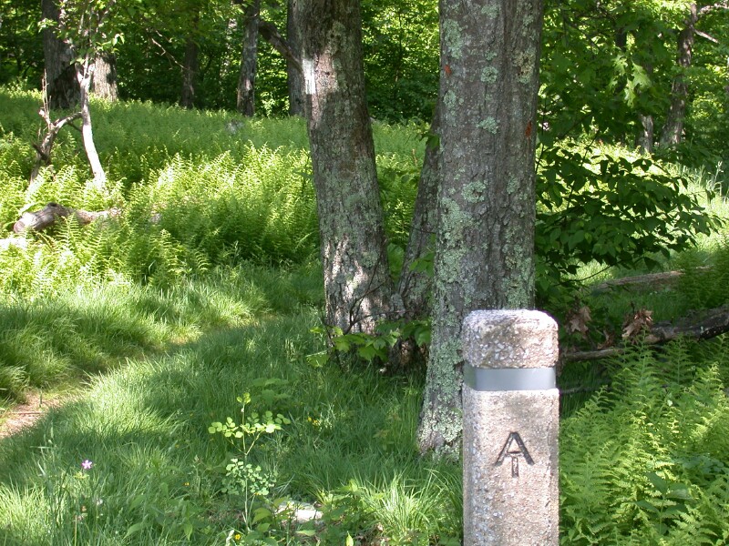
many visits over the years. Shenandoah
is memorable partly for the distinctive
concrete posts used to mark the trail intersections and the relatively
easy, grass-lined trail.
10/05 Rockfish Gap à
Blackrock 21.6 Elevation
profile
 We covered the southernmost section of
trail in Shenandoah on our most recent hike there. We drove down for the day on a fall weekend when
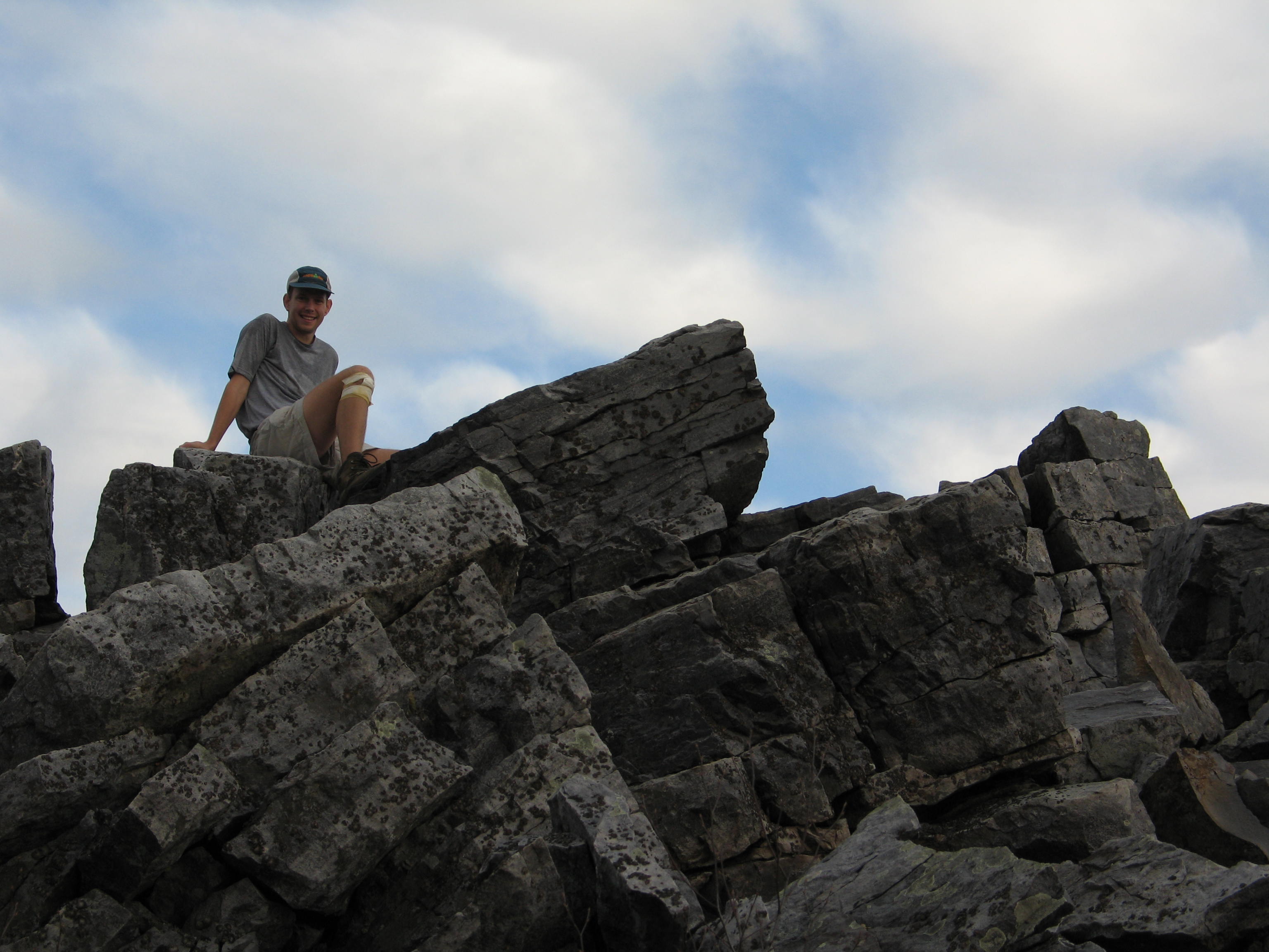
the colors were changing. I had injured
my knee in a fall while running a week earlier, and was hiking with a scraggly
bandage covering the large scraped area.
It was quite the dramatic sight.
Several hikers asked me about it to make sure I was OK. At a viewpoint near the southern end of the
section, some has placed several old
tractor seats in the ground to serve as a resting place with a view. Near the end of the section we passed the
viewpoint at Blackrock, where I had also been with some friends from church the
previous spring. We did a one night,
loop trip using the Trayfoot
Mountain and Paine Run
trails. The picture here is of me at
Blackrock; you can see the bandaged knee if you look closely.
We covered the southernmost section of
trail in Shenandoah on our most recent hike there. We drove down for the day on a fall weekend when
the colors were changing. I had injured
my knee in a fall while running a week earlier, and was hiking with a scraggly
bandage covering the large scraped area.
It was quite the dramatic sight.
Several hikers asked me about it to make sure I was OK. At a viewpoint near the southern end of the
section, some has placed several old
tractor seats in the ground to serve as a resting place with a view. Near the end of the section we passed the
viewpoint at Blackrock, where I had also been with some friends from church the
previous spring. We did a one night,
loop trip using the Trayfoot
Mountain and Paine Run
trails. The picture here is of me at
Blackrock; you can see the bandaged knee if you look closely.
6/99 Doyle
River overlook à
Loft Mtn 4.1 Elevation
profile of this area
10/15/05 Loft Mnt. à Hightop Hut 12.9
10/16/05 Hightop Hut à South
River Picnic Area 6.4
I hiked the next few miles of trail during several separate
trips. In 1999, I camped with my parents
at Loft
Mountain campground for a couple of nights in June. We did a short section of the trail near the
campground. Then in the fall of 2001
Tatiana and I did our first backpacking trip together, on the Jeremy’s Run
trail. We hiked a loop that also
included part of the AT south of Loft Mountain Campground.
In the fall of 2005 I led a backpacking trip for the Wilmington Trail Club. Christel and Nathaniel joined the group, along
with 4-5 people from Delaware,
including Mark O’Neal and George Wagner.
We camped at Big Meadows on Friday night before the hike. We started at the Loft Mountain Wayside and
took a short side trail up to the AT, then hiked north and camped at Hightop
Hut shelter. Several of us stayed in the
shelter and a few set up tents. The
weather was mild and sunny, and the colors were in full glory. On the second day I woke up not feeling well,
and struggled to complete the 6.4 miles to South River Picnic area. Fortunately Tatiana was able to drive us home
– it was several hours before I felt well enough to do anything. That energy crash led me to several doctors
visits to determine the cause, since I have experienced something similar
(though not quite as severe) several times before. We were not able to come to any conclusions,
other than to rule out neurological or endocrine abnormalities. I think the problems result from a combination
of inadequate hydration and nutrition, but it is hard to say for sure.
10/06/00 South River P.A. à
Bearfence Mnt Shelter 6.0 Elevation
profile (all three days)
10/07/00 Bearfence Mnt à Rockspring Hut 11.5
10/08/00 Rockspring à Little Stony Man 6.6
 I hiked the next section north with my
brother Mike in the fall of 2000. Mike
had several months off between his summer job in Glacier Bay and his winter job
in the Everglades, so he was traveling
around. He met up with me at Bellevue State Park, where I was coaching for an
invitational cross country meet. We
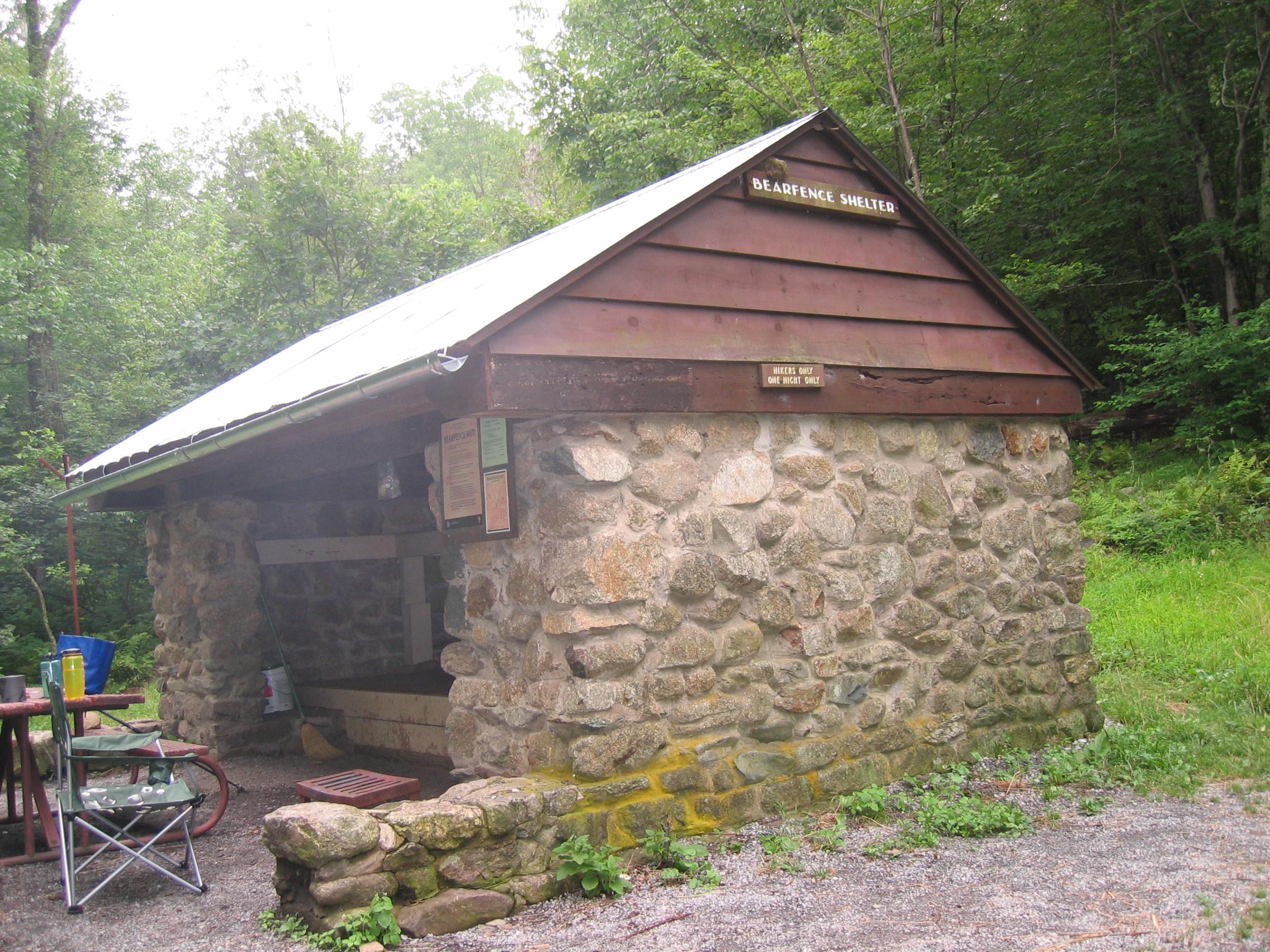
stayed at my place and drove to Shenandoah in the morning. By the time we got onto the trail I think it
was late morning or even early afternoon, but we only needed to make it 6 miles
to Bearfence
Hut. The colors were at peak and the
weather marvelous – this is a trip that I often recall fondly because of the
perfect hiking conditions. At the
shelter on the first night we met a couple of interesting characters. There was a southbound thru-hiker named
“Untraveller”, a middle-aged guy who had quit his job to hike the trail. He was quite a complainer and did not have
much good to say about anything, it seemed.
The other guys was an out-of-shape middle aged guy who was trying to
“get back into” hiking and had just come a couple of miles to the shelter. This guy queried us with all sorts of odd
questions throughout the evening. The
next day we had a nice hike to Rockspring Hut.
The route included Bearfence Mountain, which is a tricky scramble over a jumbled
rocky peak, and a lunch stop at Lewis
Falls near Big Meadows campground.
We had hiked to Lewis
Falls with the rest of
the family in 1985. We had the shelter
to ourselves that night. There was one
other hiker who set up a tent. We
enjoyed sitting on bench in front of the shelter and watch the lights of the
farms and small towns in the valley coming on as evening approached. The following day it was an easy hike past
Skyland and out to Little Stony Man parking area. We took a side trip up to Hawksbill
Peak, the highest point in the park.
I have been there several other times – on my own during spring break
one year, on a very cold morning; with Mom and Dad in 1999, and with friends
from church a couple of years ago. The
peak provides a great view of the surrounding mountains and the Shenandoah Valley.
We also enjoyed the view at Stony Man, where one can look along the
ridge of the mountains stretching north and see Skyline Drive snaking around the
mountains. I have a posted of this view
above my desk.
I hiked the next section north with my
brother Mike in the fall of 2000. Mike
had several months off between his summer job in Glacier Bay and his winter job
in the Everglades, so he was traveling
around. He met up with me at Bellevue State Park, where I was coaching for an
invitational cross country meet. We
stayed at my place and drove to Shenandoah in the morning. By the time we got onto the trail I think it
was late morning or even early afternoon, but we only needed to make it 6 miles
to Bearfence
Hut. The colors were at peak and the
weather marvelous – this is a trip that I often recall fondly because of the
perfect hiking conditions. At the
shelter on the first night we met a couple of interesting characters. There was a southbound thru-hiker named
“Untraveller”, a middle-aged guy who had quit his job to hike the trail. He was quite a complainer and did not have
much good to say about anything, it seemed.
The other guys was an out-of-shape middle aged guy who was trying to
“get back into” hiking and had just come a couple of miles to the shelter. This guy queried us with all sorts of odd
questions throughout the evening. The
next day we had a nice hike to Rockspring Hut.
The route included Bearfence Mountain, which is a tricky scramble over a jumbled
rocky peak, and a lunch stop at Lewis
Falls near Big Meadows campground.
We had hiked to Lewis
Falls with the rest of
the family in 1985. We had the shelter
to ourselves that night. There was one
other hiker who set up a tent. We
enjoyed sitting on bench in front of the shelter and watch the lights of the
farms and small towns in the valley coming on as evening approached. The following day it was an easy hike past
Skyland and out to Little Stony Man parking area. We took a side trip up to Hawksbill
Peak, the highest point in the park.
I have been there several other times – on my own during spring break
one year, on a very cold morning; with Mom and Dad in 1999, and with friends
from church a couple of years ago. The
peak provides a great view of the surrounding mountains and the Shenandoah Valley.
We also enjoyed the view at Stony Man, where one can look along the
ridge of the mountains stretching north and see Skyline Drive snaking around the
mountains. I have a posted of this view
above my desk.
10/04 Elkwallow à Little Stony Man 16.1 Elevation
profile
9/04 US 522 à Elkwallow 19.1 Elevation
profile
10/04 US 522 à Sky Meadows
State Park 17.4 Elevation
profile
 After
moving to Greenbelt in the summer of 2004, we
found ourselves within easy driving distance of the trail in northern Virginia and Maryland. I was also free of official coaching duties,
since I was only informally helping out with the team at Gonzaga. So we spent quite a few Saturdays hiking on
the AT. The first section was between
Elkwallow Wayside and Little
Stony Man. I started hiking at
Elkwallow, which is a adjacent to the Matthews Arm campground. The hiked was marked by a descent and
subsequent climb at Swift Run Gap, where we have often entered the park, and a
good viewpoint just south of the gap at Mary’s
Rock. The route also passed through
the Pinnacles picnic area, where a sign informed visitors about the AT and
invited them to stroll along the trail for a few steps – one of several similar
signs located along the trail route. We
ended the hike by scrambling up to the Stony Man viewpoint. The next section started outside the park at US route 522,
from which the trail climbs steadily to reach the main ridge in the park. Along the way I passed the popular Tom Floyd
Wayside campsite, where new campsites have recently been constructed in order
to reduce impact from overuse. There was
also a view
at Hogback Mountain . The third
section also started at route 522 and went north. There was also a bit of climbing here as the
trail passed the Smithsonian zoological research facility; I was disappointed
that a sign pictured in the guidebook, warning hikers that trespassers would be
eaten, is no longer visible on the trail route.
I think it was re-routed. The trail
descended again to cross
under I-66, then climbed gently through woods to another ridgeline and
eventually to reach Sky
Meadows State
Park.
Tatiana had discovered a new access trail to the AT when hiking up from
the park, which we used as the endpoint for the trail. I think the trail had just been cut in the
previous week or two. On returning, we
descended steeply downhill through the park along the original access trail to
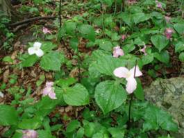
arrive at the park headquarters and parking area. I have more recently hiked in the area south
of Sky Meadows, where the trail passes through the Richard Thompson
Wildlife Management Area, operated by the state of Virginia.
The trail in that stretch is bordered by trilliums, which were in bloom
in early May.
After
moving to Greenbelt in the summer of 2004, we
found ourselves within easy driving distance of the trail in northern Virginia and Maryland. I was also free of official coaching duties,
since I was only informally helping out with the team at Gonzaga. So we spent quite a few Saturdays hiking on
the AT. The first section was between
Elkwallow Wayside and Little
Stony Man. I started hiking at
Elkwallow, which is a adjacent to the Matthews Arm campground. The hiked was marked by a descent and
subsequent climb at Swift Run Gap, where we have often entered the park, and a
good viewpoint just south of the gap at Mary’s
Rock. The route also passed through
the Pinnacles picnic area, where a sign informed visitors about the AT and
invited them to stroll along the trail for a few steps – one of several similar
signs located along the trail route. We
ended the hike by scrambling up to the Stony Man viewpoint. The next section started outside the park at US route 522,
from which the trail climbs steadily to reach the main ridge in the park. Along the way I passed the popular Tom Floyd
Wayside campsite, where new campsites have recently been constructed in order
to reduce impact from overuse. There was
also a view
at Hogback Mountain . The third
section also started at route 522 and went north. There was also a bit of climbing here as the
trail passed the Smithsonian zoological research facility; I was disappointed
that a sign pictured in the guidebook, warning hikers that trespassers would be
eaten, is no longer visible on the trail route.
I think it was re-routed. The trail
descended again to cross
under I-66, then climbed gently through woods to another ridgeline and
eventually to reach Sky
Meadows State
Park.
Tatiana had discovered a new access trail to the AT when hiking up from
the park, which we used as the endpoint for the trail. I think the trail had just been cut in the
previous week or two. On returning, we
descended steeply downhill through the park along the original access trail to
arrive at the park headquarters and parking area. I have more recently hiked in the area south
of Sky Meadows, where the trail passes through the Richard Thompson
Wildlife Management Area, operated by the state of Virginia.
The trail in that stretch is bordered by trilliums, which were in bloom
in early May.
8/03 VA 7 Snickers Gap à Rod Hollow Shelter 10.4 Elevation
profile of trip
8/03 Rod Hollow à Sky Meadows 6.7
The next two sections were part of a backpacking trip on
August of 2003, the year that we were married.
I was trying to figure out if I could handle a week or more on the
trail, and decided to start at Snickers Gap because I had done most of the
trail north of there through Pennsylvania. I started hiking south from Snickers Gap,
through a section known as the “roller
coaster” – and so named because the trail climbs and descends 8 or 10 small
mountains through this stretch, and is never level. Because of private ownership and development
issues, the trail actually moves away from the ridge top in this stretch – and
therefore settles for taking this up and down route as an alternate. After the initial climb from route 7 I
reached a nice
viewpoint at Bear’s Den, which is near a Hostel by the same name. Beyond that point there was little reward for
the climbing in the way of views. The
weather was hot, humid, and miserable – certainly the worst I have ever
experienced for hiking. I felt crummy
and it did not seem like I could drink enough water. I was the only one staying at the Rod
Hollow shelter. I remember that I
had my AT Databook with me, which contains a succinct list of all the important
trail data – shelters, road crossings, water, etc. I used it to get a sense of how much of the
trail I had already done, and began dreaming in a more concrete way about
hiking the entire trail. The shelter’s
water source featured a “trail shower” – a trough had been installed,
downstream from where people would collect drinking water, to allow water to
fall from 3 feet off the ground – so you could get under for a sort of camp
shower. The next day I felt a bit “under
the weather” when I woke up, and continued to feel worse as I hiked. I crossed Ashby Gap and US route 50, a road
which I now drive on regularly during my commute (in Washington
DC) and which Mike lives near on in Gunnison, CO. The climb after the road crossing, although
relatively easy by AT standards, wore me out, and when I reached Sky Meadows I
decided I could go no further. I called
Tatiana from the park and asked her to pick me up. While waiting for a ride, I did get to enjoy
the rustic surroundings of the park – a historic stone house and outbuildings,
as well as a small visitor center/store.
I had hoped to continue for several more days into Shenandoah, but that
would have to wait. On a more recent
visit to this area, I found that the trail has been relocated within Sky Meadows
State Park to take
advantage of grassy,
open terrain.
6/21/03 Weaverton
à
Snickers Gap 23.3 Detail map of
Maryland section | Elevation
profile of Maryland | Elevation
Profile of this section
 I
hiked this section of trail with a small group from the Wilmington Trail Club, only a
few weeks before our wedding. I was
staying with Tatiana at Doug and Nancy’s in Hampstead, and I drove down to I-70
and met the club group as they were driving west, riding with Jim March. We parked a car at Snickers
Gap and then shuttled back to Weaverton, which is just above the C&O Canal
in Maryland. From there the trail descends under
US 340 to the Canal and follows
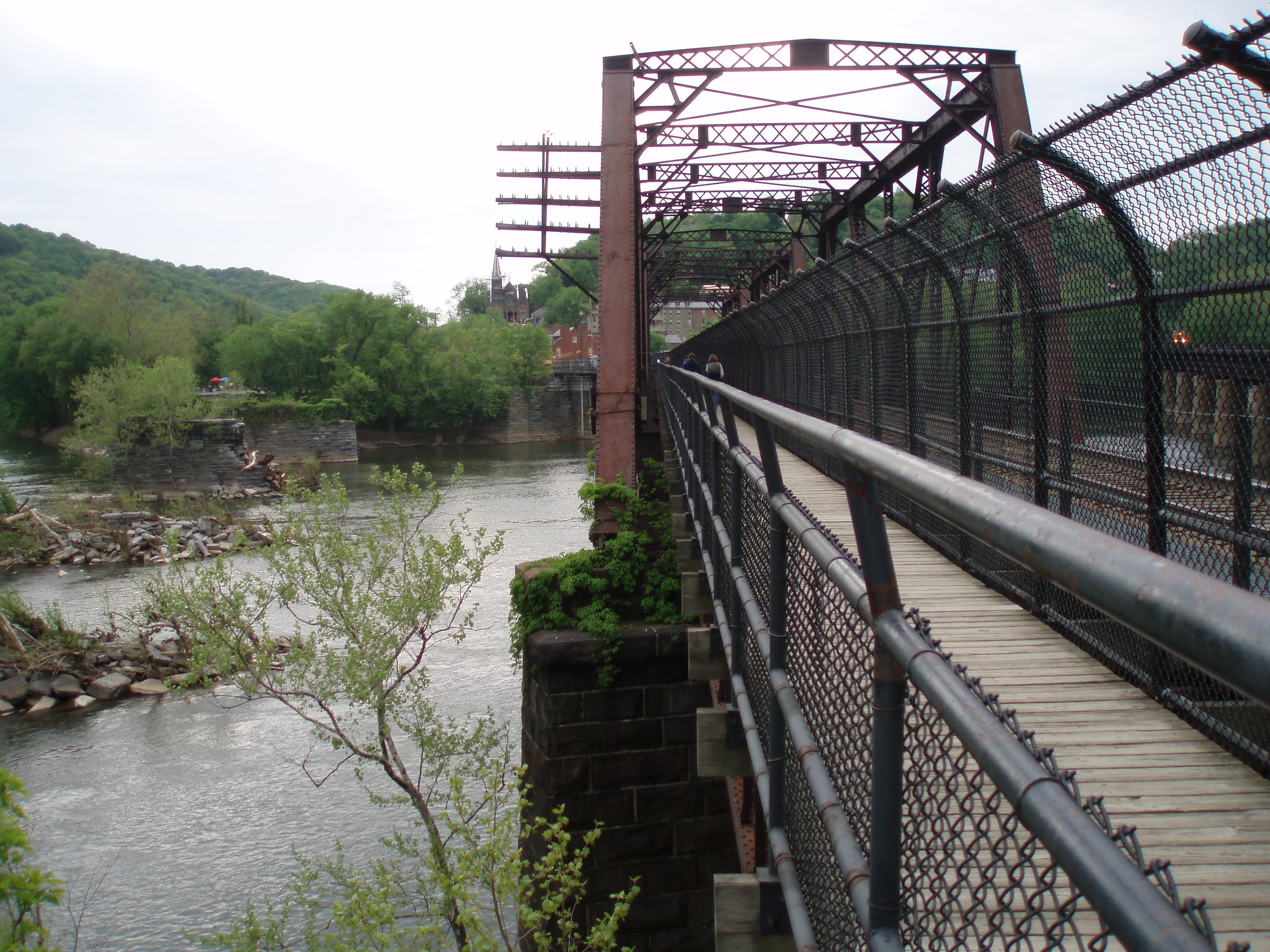
the Towpath for 3 miles into Harpers Ferry. This is probably the easiest
three miles of the entire trail, and one of the few sections where bikes
are permitted. The trail crosses the
Potomac on a railroad bridge, just upstream from where the Shenandoah joins the
Potomac.
Harpers Ferry occupies the peninsula of
land formed by the intersection of the two rivers. We passed through Harpers
Ferry while things were still quiet, and hurried on through
because there was still a long ways to go.
We paused at Jefferson
Rock, where Thomas Jefferson reportedly exclaimed, upon viewing the Shenandoah River
and the mountains beyond that the trip across the Atlantic
was worth undertaking just for that view.
The trail soon crossed
the Shenandoah on a highway bridge, and then climbed steeply to reach the
ridge top, after which it soon crosses into Virginia.
Toward the end of the hike we paused again at a viewpoint
where we met several through hikers. As
light rain began to fall, they mentioned to us that there had only been a
handful of days in the past month without any rain. We stopped for dinner after picking up the
car, and arrived home rather late. The
trail club has decided not to day-hike this section any more, since it takes
such a long time to drive from Delaware
and do the hike.
I
hiked this section of trail with a small group from the Wilmington Trail Club, only a
few weeks before our wedding. I was
staying with Tatiana at Doug and Nancy’s in Hampstead, and I drove down to I-70
and met the club group as they were driving west, riding with Jim March. We parked a car at Snickers
Gap and then shuttled back to Weaverton, which is just above the C&O Canal
in Maryland. From there the trail descends under
US 340 to the Canal and follows
the Towpath for 3 miles into Harpers Ferry. This is probably the easiest
three miles of the entire trail, and one of the few sections where bikes
are permitted. The trail crosses the
Potomac on a railroad bridge, just upstream from where the Shenandoah joins the
Potomac.
Harpers Ferry occupies the peninsula of
land formed by the intersection of the two rivers. We passed through Harpers
Ferry while things were still quiet, and hurried on through
because there was still a long ways to go.
We paused at Jefferson
Rock, where Thomas Jefferson reportedly exclaimed, upon viewing the Shenandoah River
and the mountains beyond that the trip across the Atlantic
was worth undertaking just for that view.
The trail soon crossed
the Shenandoah on a highway bridge, and then climbed steeply to reach the
ridge top, after which it soon crosses into Virginia.
Toward the end of the hike we paused again at a viewpoint
where we met several through hikers. As
light rain began to fall, they mentioned to us that there had only been a
handful of days in the past month without any rain. We stopped for dinner after picking up the
car, and arrived home rather late. The
trail club has decided not to day-hike this section any more, since it takes
such a long time to drive from Delaware
and do the hike.
9/04 Weaverton
à
Wash. Monument
SP 15.7
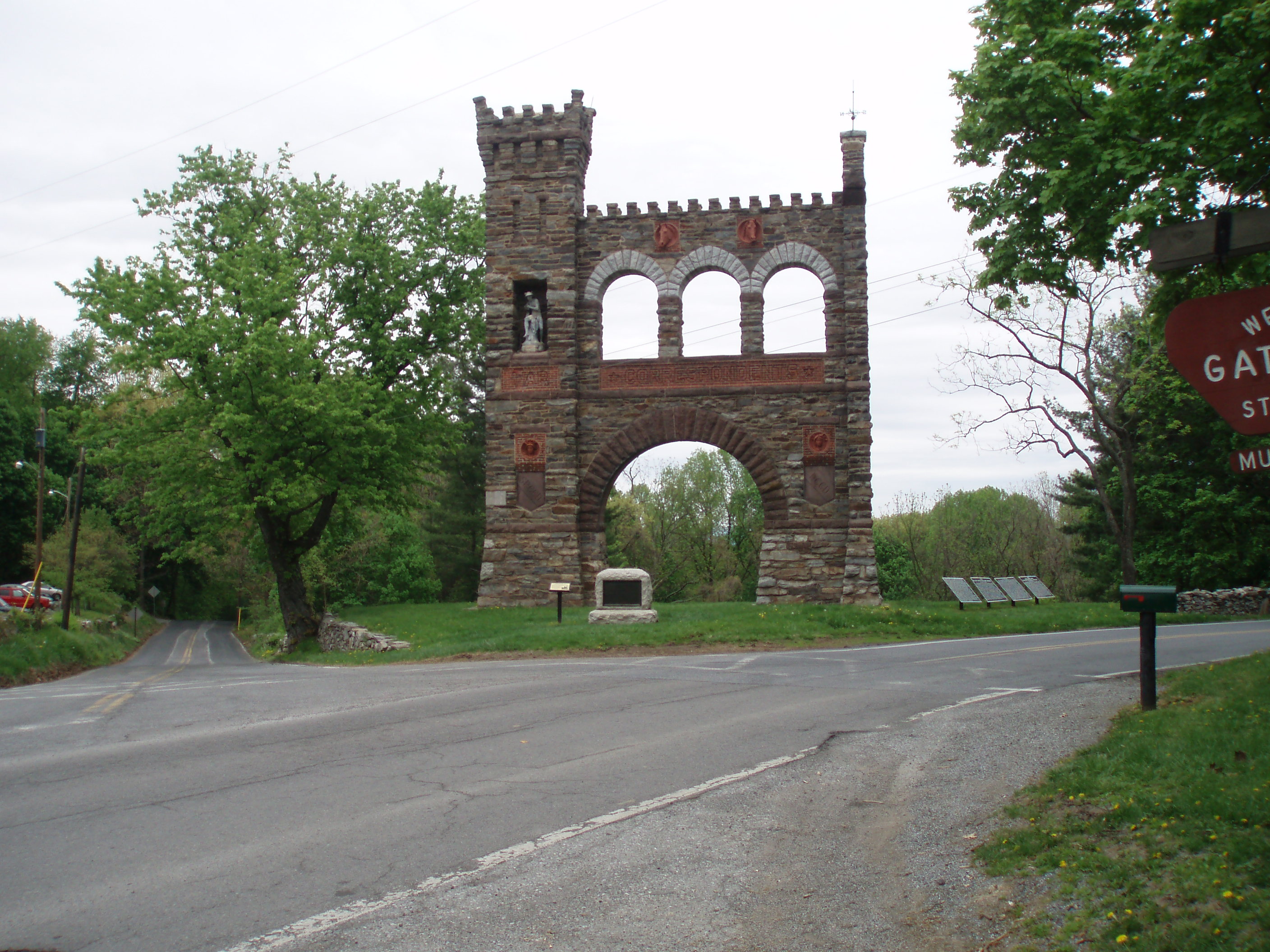
 We
hiked this easy section of trail during the fall we moved to Greenbelt.
It was one of our many AT hikes that fall, when we frequently enjoyed
the changing colors and mild weather in the mid-Atlantic. I started at Weaverton and after climbing up
to the ridge found this to be an very easy hike. The trail is fairly level and one can move
along quite quickly. Towards the middle
of the section I passed through Gathland
State Park, where a large
monument (pictured here at left) has been erected to “war
correspondents”. A series of civil war
battles was fought along the ridge tops in the area. We ended by passing through the Dahlgren
backpacker campsite and up to Washington
Monument State
Park.
We
hiked this easy section of trail during the fall we moved to Greenbelt.
It was one of our many AT hikes that fall, when we frequently enjoyed
the changing colors and mild weather in the mid-Atlantic. I started at Weaverton and after climbing up
to the ridge found this to be an very easy hike. The trail is fairly level and one can move
along quite quickly. Towards the middle
of the section I passed through Gathland
State Park, where a large
monument (pictured here at left) has been erected to “war
correspondents”. A series of civil war
battles was fought along the ridge tops in the area. We ended by passing through the Dahlgren
backpacker campsite and up to Washington
Monument State
Park.
8/30/97 Old Forge Picnic Area à Devils Racecourse 12.1 Elevation
profile of trip
8/31/97 Devil’s Racecourse à Pogo campsite 9.7
9/1/97 Pogo campsite à Wash Monument
SP 7.2
I hiked this section as a member of the second backpacking
trip I ever did with the Wilmington Trail Club – and my first backpacking trip
on the AT. I rode to the trailhead with
Alice Vernier from Newark. When I left my car at her house I met her
husband Vern, who I later learned was a former AT thru-hiker. Vern, who went by the name “Del Doc” (I think
he was a PhD chemist), did some GPS mapping for the Appalachian Trail
Conference in the 90s, and his name is now credited on some of the newer trail
maps that have been issued by the ATC.
Robin Kershaw and Brad Gruver, both of whom I had met on an earlier
backpacking trip and with him I would hike on several other WTC trips, joined
us. We stayed at the Dahlgren
backpacker’s campsite near Old US 40.
This campsite is unique because it is equipped with a concrete-block
bathroom building that has running water and showers. The next morning we shuttled up to our start
point at Old
Forge Picnic Area in Pennsylvania. By afternoon we had reached Penmar (pictured
here), a historic resort town on the border between Pennsylvania
and Maryland. The park in town offers a view
of the countryside to the west. Alice was not feeling
well, and decided to call her husband for ride – so the three of us continued
without her. We camped in our tents at the
Devils Racecourse shelter. The next
morning we stopped for a break at another shelter and met a rather interesting
family, which was in the midst of packing up.
The family consisted of 2 parents and 4 children, ranging in age from
perhaps 8 to 14. There were some
interesting dynamics going on, and it seemed that the father was sort of
“dragging” the group into the woods for the weekend. We continued down the trail to the Pogo
campsite. After we had been set up for a
couple of hours, our new friends straggled into the camping area and set up
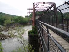
nearby. The next morning we continued
south, crossing
I-70 on a dedicated pedestrian bridge and ending at Washington
Monument State Park. The park was
the first monument dedicated to our first president, and is marked by a large
stone tower with a view of the surrounding area. Upon completion of the hike, I drove Alice’s car back to Newark,
since she had left us early.
 Tatiana
and I recently hiked this entire stretch again, along with the rest of the Maryland section, as
part of the Hike Across Maryland.
This supported event involves trekking the entire 41 miles of trail in Maryland, starting at Penmar at 5:00am and ending at Harpers Ferry. We
carried little, walked quickly, and stopped only briefly at checkpoints for
more water and food. The longest
checkpoint, for lunch, was at Washington
Monument. The route is relatively
easy, with a few rocky sections and climbs but also lots of relatively level
ridge walking and a few farms. It was a fun event – and the first time we
had ever walked 40 miles in one day! The
picture here is from a viewpoint north of I-70.
Tatiana
and I recently hiked this entire stretch again, along with the rest of the Maryland section, as
part of the Hike Across Maryland.
This supported event involves trekking the entire 41 miles of trail in Maryland, starting at Penmar at 5:00am and ending at Harpers Ferry. We
carried little, walked quickly, and stopped only briefly at checkpoints for
more water and food. The longest
checkpoint, for lunch, was at Washington
Monument. The route is relatively
easy, with a few rocky sections and climbs but also lots of relatively level
ridge walking and a few farms. It was a fun event – and the first time we
had ever walked 40 miles in one day! The
picture here is from a viewpoint north of I-70.
Pennsylvania maps: overall
| south | north
3/13/04 Shippensburg
Rd à
Old Forge Picnic Area (Caledonia) 22.0
3/27/04 Sherwood
Rd à
Old Town Rd (Cumberland Valley) 18.8
10/04 Old
Town Rd à
Shippensburg Rd (Pine Grove) 20.6
Elevation maps: Caledonia
State Park | Cumberland
Valley | Pine
Grove Furnace State Park
This series of hikes represented our first attempts at doing
linear section hikes with Tatiana dropping me off on one end and then hiking
toward me from the other end of the section.
We wanted to take advantage of some free weekends in March, before the
track season started. We started with the
southernmost section in Pennsylvania. The drive to the trailhead took us through
Gettysburg and then up a long hill to a high point on Shippensburg
Rd, where I started hiking southbound.
It was cold weather for hiking – I started out with a warm hat and
gloves – but I warmed up as I got going.
Towards the mid-point of the hike the trail descended towards Caledonia State Park, and I paused at the Quarry
Gap Shelters. The term is plural
because at this campsite, as well as several others in southern Pennsylvania, a pair
of shelters was built. At Quarry
Gap, the two
shelters share a common roof, and the in space between the two structures
was a picnic table. The maintainers have
also created a rock-lined
corridor for the water source, a stream that passes in front of the
shelters. At the bottom of the hill I
passed through Caledonia
State Park, where I had camped with my family in 1985. We used the park as a base camp for exploring
Gettysburg. The park, like many others in Pennsylvania, has rustic
CCC era facilities in a wooded setting. Shortly
after crossing US route 30 I met up with Tatiana. The trail continued along a wooded ridgeline,
occasionally
following a rocky route along the very top of the ridge and occasionally
dropping down to parallel the rocks on an easier route. At one point we had a view of some sort of
educational facility from far above. As
we neared the end of the hike I recognized the Old
Forge Picnic Area, where we had parked cars for the first backpacking trip
I had done on the AT several years before.
 We had another free Saturday later in the
month, and expected to work north from Shippensburg Road this time. But weather conditions intervened – we had a
rare late-season snowstorm, and were concerned there might be too much snow for
hiking at higher elevations. Se we shifted
north to hike one of the most unusual sections of the entire trail – the
crossing of the Cumberland
Valley. At this valley crossing southwest of Harrisburg, the trail
leaves the mountains for 18 miles, and winds its way across
farms and small woodlots. The route
crosses three major
highways, including the Pennsylvania Turnpike, as well as a railroad track
and numerous smaller roads. The route
also crosses a medium-sized
river called Conodoguinet Creek.
Snow was still present on some of the more shaded sections of trail, but
not much. Towards the end of the section
the trail passes through the small town of Boiling Springs, where the Appalachian Trail
Conservancy has a regional office.
Tatiana had sustained a minor knee injury, and decided not to hike, so
she met me in Boiling
Springs, where a well-used crushed stone trail follows
a small lake through town. A few
miles south of town the trail climbed back into denser woods, and crossed
a rocky area. I had hiked a short
section here in 1995 or 96, while visiting a college friend, Karen Dreyer, who
was working as a Resident Director at nearby Messiah College at the time. The section ended at a gravel road in a
wooded area.
We had another free Saturday later in the
month, and expected to work north from Shippensburg Road this time. But weather conditions intervened – we had a
rare late-season snowstorm, and were concerned there might be too much snow for
hiking at higher elevations. Se we shifted
north to hike one of the most unusual sections of the entire trail – the
crossing of the Cumberland
Valley. At this valley crossing southwest of Harrisburg, the trail
leaves the mountains for 18 miles, and winds its way across
farms and small woodlots. The route
crosses three major
highways, including the Pennsylvania Turnpike, as well as a railroad track
and numerous smaller roads. The route
also crosses a medium-sized
river called Conodoguinet Creek.
Snow was still present on some of the more shaded sections of trail, but
not much. Towards the end of the section
the trail passes through the small town of Boiling Springs, where the Appalachian Trail
Conservancy has a regional office.
Tatiana had sustained a minor knee injury, and decided not to hike, so
she met me in Boiling
Springs, where a well-used crushed stone trail follows
a small lake through town. A few
miles south of town the trail climbed back into denser woods, and crossed
a rocky area. I had hiked a short
section here in 1995 or 96, while visiting a college friend, Karen Dreyer, who
was working as a Resident Director at nearby Messiah College at the time. The section ended at a gravel road in a
wooded area.
We had hoped to hike the missing section before moving to Greenbelt, when we would
be farther away, but we could not fit it in.
So the following fall, during our most active hiking season ever (taking
advantage of fewer coaching obligations) we headed back to this part of Pennsylvania. I started at the northern end of the section
and headed south. The most memorable
aspect of this hike was passing the large sign that
marks the mid-point of the trail – halfway between Springer and
Katahdin. The technical mid-point
changes from year to year, as relocations alter the actual distance of the
trail – but the
sign was pretty close. Shortly after
passing the sign I strolled through Pine
Grove Furnace State Park. The part
has a historic house, which serves as a hostel.
Thru-hikers often purchase a half gallon of ice cream from the nearby
camp store, and attempt to consume the entire container – as a marker of their
“halfway” status. I met up with Tatiana
a mile beyond the state park, and we walked together back to the parking area
on Shippensburg Road.
11/01? Clark’s Ferry à
Sherwood Rd 15.4 Elevation
profile
 The next
section north of the Cumberland Valley crosses a ridgeline and then drops down to Duncannon, PA, where it
crosses the Susquehanna River. I hiked this section with a group from the
Wilmington Trail club in the late fall one year. We had a short amount of daylight to work
with, as well as a long drive from Delaware,
so we hurried along on our hike. We
started at Clark’s Ferry, on the northeast
side of the Susquehanna. The trail
crosses rivers on two major highway bridges – first over the Susquehanna and
then the Juniata. The rivers crossings were followed by an easy
“warm-up” stroll through the streets of Duncannon, which is a popular re-supply
town for thru-hikers. After climbing to
the ridge, the trail intersects
with the Tuscarora Trail, which is an alternate western route through the
mid-Atlantic region. The Tuscarora
trail was developed in the 1960s, when trail advocates were concerned that
the original trail route might give way to encroaching development. The National Trails Act of 1968 helped
preserve the original trail, but the Tuscarora still exists as an alternate
route. It rejoins the AT in the northern
part of Shenandoah
National Park. This section ended a short distance past PA
route 944, where a narrow busy road with no parking prevents challenges for
dayhikers (a tunnel was built under this road in 2008)
The next
section north of the Cumberland Valley crosses a ridgeline and then drops down to Duncannon, PA, where it
crosses the Susquehanna River. I hiked this section with a group from the
Wilmington Trail club in the late fall one year. We had a short amount of daylight to work
with, as well as a long drive from Delaware,
so we hurried along on our hike. We
started at Clark’s Ferry, on the northeast
side of the Susquehanna. The trail
crosses rivers on two major highway bridges – first over the Susquehanna and
then the Juniata. The rivers crossings were followed by an easy
“warm-up” stroll through the streets of Duncannon, which is a popular re-supply
town for thru-hikers. After climbing to
the ridge, the trail intersects
with the Tuscarora Trail, which is an alternate western route through the
mid-Atlantic region. The Tuscarora
trail was developed in the 1960s, when trail advocates were concerned that
the original trail route might give way to encroaching development. The National Trails Act of 1968 helped
preserve the original trail, but the Tuscarora still exists as an alternate
route. It rejoins the AT in the northern
part of Shenandoah
National Park. This section ended a short distance past PA
route 944, where a narrow busy road with no parking prevents challenges for
dayhikers (a tunnel was built under this road in 2008)
4/04 Clark’s Ferry à
Swatara Gap 32.1 Elevation
profile
 Before
moving to Greenbelt, we made an attempt to
finish the trail through Pennsylvania and New Jersey. We were not quite able to accomplish that
goal, but we did manage to hike the section north of the Susquehanna, which
turned out to be our longest unsupported hike in the entire endeavor. We had the option of hiking 32 miles all at
once, or breaking the hike into 2 shorter journeys. Since the one-way drive to the trail from our
townhouse in Northeast was between 1 and 2 hours, we decided to minimize the
driving and go for the long hike. We
left early one morning and I was on the trail in Clark’s
Ferry by 8:00 am. I started by crossing
a busy
railroad corridor and then quickly climbed up to the ridge top. There were several views
of the Susquehanna river valley along the way. I took a break at a new
shelter along the ridge. Partway
through the hike the trail crosses route 225, where a pedestrian bridge had
recently been built over the road, which otherwise presented an unsafe crossing
because of a blind
turn at the top of a hill . The
trail dropped into a scenic
gap along a creek lined with rhododendron, crossed route 325, then climbed
steadily to the intersection
with the Horseshoe Trail, where I met
Tatiana. The Horseshoe Trail travels
straight east, across farmland and through woods, all the way to Valley Forge.
Towards the northern end of the section we passed through Rausch Gap,
where a mining community formerly occupied the now-wooded terrain. The legacy of mining is evident in the
pollution mitigation structure that had been installed on a creek to treat
acid mine drainage by forcing the water to flow through limestone, raising
the pH. In the late afternoon we reached
the car at
Swatara Gap, where a new state park is being developed. At this point there are no facilities, only
protected land.
Before
moving to Greenbelt, we made an attempt to
finish the trail through Pennsylvania and New Jersey. We were not quite able to accomplish that
goal, but we did manage to hike the section north of the Susquehanna, which
turned out to be our longest unsupported hike in the entire endeavor. We had the option of hiking 32 miles all at
once, or breaking the hike into 2 shorter journeys. Since the one-way drive to the trail from our
townhouse in Northeast was between 1 and 2 hours, we decided to minimize the
driving and go for the long hike. We
left early one morning and I was on the trail in Clark’s
Ferry by 8:00 am. I started by crossing
a busy
railroad corridor and then quickly climbed up to the ridge top. There were several views
of the Susquehanna river valley along the way. I took a break at a new
shelter along the ridge. Partway
through the hike the trail crosses route 225, where a pedestrian bridge had
recently been built over the road, which otherwise presented an unsafe crossing
because of a blind
turn at the top of a hill . The
trail dropped into a scenic
gap along a creek lined with rhododendron, crossed route 325, then climbed
steadily to the intersection
with the Horseshoe Trail, where I met
Tatiana. The Horseshoe Trail travels
straight east, across farmland and through woods, all the way to Valley Forge.
Towards the northern end of the section we passed through Rausch Gap,
where a mining community formerly occupied the now-wooded terrain. The legacy of mining is evident in the
pollution mitigation structure that had been installed on a creek to treat
acid mine drainage by forcing the water to flow through limestone, raising
the pH. In the late afternoon we reached
the car at
Swatara Gap, where a new state park is being developed. At this point there are no facilities, only
protected land.
10/05 Swatara Gap à PA 183 22.1 Elevation
profile
This section in Pennsylvania
was one that we could not manage to fit in while we were still living in Delaware or Cecil
County. I started hiking at Swatara
Gap, where the trail initially parallels and then crosses the Schuylkill
River on an old
iron bridge. The trail also crosses
underneath I-81, which was under construction and passes over on a very
high, elevated section. After reaching
the ridgeline I came upon a family who were breaking camp after staying the
night in a campsite next to the trail.
There were several views
from the ridge. After meeting up
with Tatiana we continued north. After
crossing route 501 we came upon an interesting shelter (which is very
creatively called the
501 shelter). The shelter, rather
than the typical three-sided wooden structure with a wooden sleeping platform,
is a large 4-sided
building with a concrete floor and bunk beds. There was a table in the middle of the room,
and a skylight above to improve the inside environment. A nearby homeowner takes care of the shelter,
and also allows hikers to use their phone to order pizza, which is delivered to
the road crossing.
5/00? Port Clinton
à
PA 183 14.4 Elevation
profile
I can’t recall for certain when I hiked this section. The hike was with the Wilmington Trail Club,
and was led by Bill Tinney. I remember
climbing a steep slope out of Port Clinton, and that the trail remained quite
level for the remainder of the section.
This section is typical of the northern half of the trail in Pennsylvania in having
lots of rocks. Across the trail are
strewn what seem like piles
of rocks, mostly of similar size and shape to a football or
volleyball. They make for rather
difficult walking. It is this sort
of terrain that makes hikers refer to Pennsylvania
as “the
place where boots go to die”.
Thankfully, some sections in Pennsylvania
are also very flat, following old
roads along the top of a ridge for miles.
5/99? Hawk Mnt. Rd à Port Clinton 15.2 Elevation
profile
 This is one of the more interesting
sections in Pennsylvania. I hiked it with a group from the Wilmington
Trail Club on a warm Saturday. The
highlight of the hike was the view from a rock outcropping known as the Pinnacle. At this location there is a sharp bend in the
ridge, such that hikers have a 270
degree view from the point. We
admired the pastoral
farmland view and also spotted a rattlesnake on the rocks. There was also a viewpoint at Pulpit
Rock. The route also passed through
a grassy section near the Hamburg
reservoir. After the hike we stopped at
a pub in Port Clinton, which is frequented by hikers. This section also passes the site of Windsor
Furnace, pictured here.
This is one of the more interesting
sections in Pennsylvania. I hiked it with a group from the Wilmington
Trail Club on a warm Saturday. The
highlight of the hike was the view from a rock outcropping known as the Pinnacle. At this location there is a sharp bend in the
ridge, such that hikers have a 270
degree view from the point. We
admired the pastoral
farmland view and also spotted a rattlesnake on the rocks. There was also a viewpoint at Pulpit
Rock. The route also passed through
a grassy section near the Hamburg
reservoir. After the hike we stopped at
a pub in Port Clinton, which is frequented by hikers. This section also passes the site of Windsor
Furnace, pictured here.
6/98? Bake
Oven Knob
à
Hawk Mountain 16.4 Elevation
profile
 I
was the hike leader for a Wilmington Trail Club hike that covered this section –
the only time I served as a leader for a Saturday hike. I found it difficult to be a hike leader,
because my coaching schedule meant that I was not available for most fall and
spring Saturdays, and I would spend a large portion of the summer getting away
from the mid-Atlantic humidity. For this
hike we started at a State Game Lands parking area near Bake
Oven Knob, and hiked southbound on the trail. The end of the section was at another State
Game Lands parking area, just past the paved road that leads to Hawk Mountain. [Much of the trail in Pennsylvania passes through state-owned land
on which hunting is permitted; wise hikers wear orange in the fall]. Hawk
Mountain, accessible via
a side trail from the AT, is a private wildlife preserve, situated in a
location along the major migratory flyway for hawks and other raptors. Many birdwatchers convene at the park,
especially in autumn, to watch for migrating birds. On a peak day observers will document dozens,
perhaps hundreds, or large predatory birds overhead. The place has an interesting history that
reflects changing attitudes towards predators in our culture. In the 1800s, hunters would go to Hawk Mountain
to shoot the birds – not for food, but because predators were viewed as an evil
we needed to rid ourselves of. In the early
1900s, a private citizen purchased the mountaintop to protect the birds. It is hard to imagine people hunting hawks
today. We also crossed
PA route 309 and took a break at the Allentown
Shelter.
I
was the hike leader for a Wilmington Trail Club hike that covered this section –
the only time I served as a leader for a Saturday hike. I found it difficult to be a hike leader,
because my coaching schedule meant that I was not available for most fall and
spring Saturdays, and I would spend a large portion of the summer getting away
from the mid-Atlantic humidity. For this
hike we started at a State Game Lands parking area near Bake
Oven Knob, and hiked southbound on the trail. The end of the section was at another State
Game Lands parking area, just past the paved road that leads to Hawk Mountain. [Much of the trail in Pennsylvania passes through state-owned land
on which hunting is permitted; wise hikers wear orange in the fall]. Hawk
Mountain, accessible via
a side trail from the AT, is a private wildlife preserve, situated in a
location along the major migratory flyway for hawks and other raptors. Many birdwatchers convene at the park,
especially in autumn, to watch for migrating birds. On a peak day observers will document dozens,
perhaps hundreds, or large predatory birds overhead. The place has an interesting history that
reflects changing attitudes towards predators in our culture. In the 1800s, hunters would go to Hawk Mountain
to shoot the birds – not for food, but because predators were viewed as an evil
we needed to rid ourselves of. In the early
1900s, a private citizen purchased the mountaintop to protect the birds. It is hard to imagine people hunting hawks
today. We also crossed
PA route 309 and took a break at the Allentown
Shelter.
8/97 Bake Oven Knob à Little Gap 13.7 Elevation
profile
This was the first long section (more than a mile or two) of
the AT that I ever hiked. It was a group
hike with the Wilmington Trail Club, lead by a character named Mike
Kintner. Though recently retired 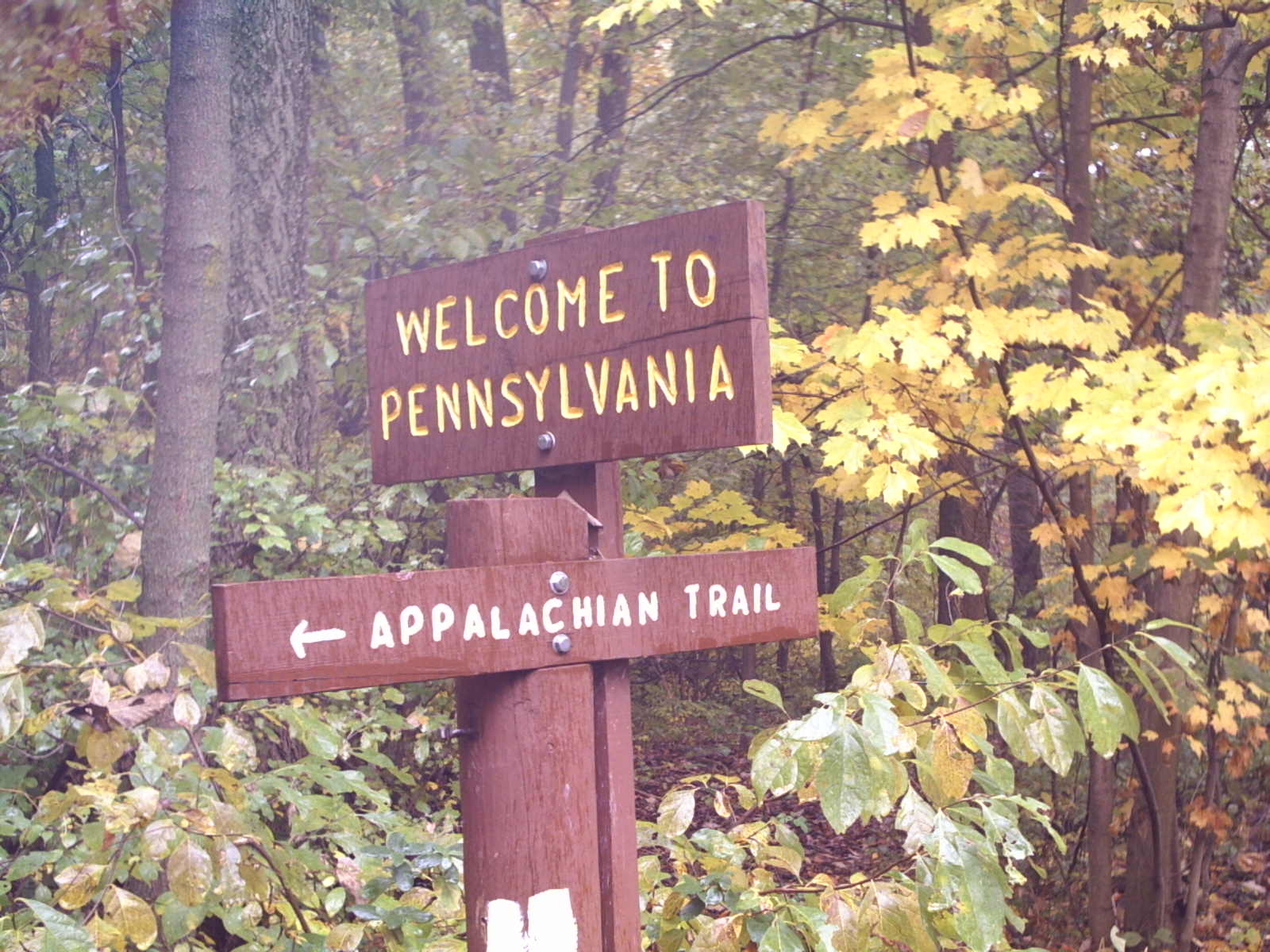 and driving a modest SUV, he would
constantly remark about his advanced age of 80+ years, and warn people against
harming his $80,000 car. Mike actually
completely a section hike of the AT several years ago, partly with the
remarkable feat of day-hiking the entire 100 mile “wilderness” section in Maine
– a endeavor which requires miles of driving on private logging roads in order
to access the trail. We hiked on one of the hottest days of the year, through a
section that is difficult on hot days for a couple of reasons. First, midway through the hike, after
crossing the Lehigh
River, we had to climb a rocky,
exposed mountain north of Lehigh Gap – a climb with the well-deserved
reputation as the toughest climb
in Pennsylvania (an I would add that it’s probably tougher than anything as
far south as Dragon’s Tooth and as far north as Bear Mountain
Connecticut). The route also passed
through the only section of trail that is in a designated Superfund site. The ridgetop above Palmerton is devoid
of trees and most other vegetation as a result of repeated
exposure to emissions from a zinc-smelting
factory in the valley below, near the town of Palmerton.
Several hikers ran out of water and became exhausted during this long
hike in the sun. The other
interesting feature of the section is that the trail crosses the mountain
through which the Northeast Extension of the Pennsylvania Turnpike – a road
carrying heavy weekend traffic because it provides Philadelphia residents access to the
mountains – passes in a tunnel. The road
can be seen far below from the trail. I
also recall that on this hike I was introduced to trail club member Paul Henry
(no relation to the deceased Michigan
congressmen who spoke at my high school graduation, of the same name). Paul was hiking his last AT section in Pennsylvania, and would
later join me on numerous hiking and ski trips with the trail club.
and driving a modest SUV, he would
constantly remark about his advanced age of 80+ years, and warn people against
harming his $80,000 car. Mike actually
completely a section hike of the AT several years ago, partly with the
remarkable feat of day-hiking the entire 100 mile “wilderness” section in Maine
– a endeavor which requires miles of driving on private logging roads in order
to access the trail. We hiked on one of the hottest days of the year, through a
section that is difficult on hot days for a couple of reasons. First, midway through the hike, after
crossing the Lehigh
River, we had to climb a rocky,
exposed mountain north of Lehigh Gap – a climb with the well-deserved
reputation as the toughest climb
in Pennsylvania (an I would add that it’s probably tougher than anything as
far south as Dragon’s Tooth and as far north as Bear Mountain
Connecticut). The route also passed
through the only section of trail that is in a designated Superfund site. The ridgetop above Palmerton is devoid
of trees and most other vegetation as a result of repeated
exposure to emissions from a zinc-smelting
factory in the valley below, near the town of Palmerton.
Several hikers ran out of water and became exhausted during this long
hike in the sun. The other
interesting feature of the section is that the trail crosses the mountain
through which the Northeast Extension of the Pennsylvania Turnpike – a road
carrying heavy weekend traffic because it provides Philadelphia residents access to the
mountains – passes in a tunnel. The road
can be seen far below from the trail. I
also recall that on this hike I was introduced to trail club member Paul Henry
(no relation to the deceased Michigan
congressmen who spoke at my high school graduation, of the same name). Paul was hiking his last AT section in Pennsylvania, and would
later join me on numerous hiking and ski trips with the trail club.
11/22/03 Little Gap à Wind Gap 15.4 Elevation
profile
Tatiana and I hiked this section on a Saturday hike with the
Wilmington Trail Club – the only such hike Tatiana ever had the opportunity to
join. It was a fairly large group,
especially considering the late fall cool weather on the Saturday before
Thanksgiving. The section was fairly
unremarkable, except for the usual
rocks, negotiation of which was made more challenging by the recently
fallen leaves. There is a view
at Wolf Rocks, where I had turned around after hiking from Delaware Water
Gap a few years earlier. There was also
a view
from a powerline – another common feature of the Pennsylvania trail. There was one notable event during the hike,
as club member Andy Suna fell and cut his forehead when his glasses broke. We stopped to each at a diner in Wind Gap
before heading home – the same place where
I had eaten with a club group after leading a backpacking trip in Pennsylvania earlier
that year.
5/04 Wind Gap à Fox Gap 8.6
Map
of Delaware River to Hudson River
5/04 Delaware
Water Gap à
Blairstown Rd 12.7 Elevation
profile
5/04 High Point
SP à
Vernon 20.6 Elevation
profile
We hiked these the first two sections listed on the same day
in May of 2004, while on a scouting weekend for a backpacking trip I was to
lead for the Wilmington Trail Club later that spring. We drove up on a Saturday morning, and I
started hiking at Wind Gap, where we had ended the previous hike with the
Wilmington Trail Club. It was a fairly
un-remarkable rocky section, with one viewpoint (Wolf Rocks) near the northern
end.  After finishing
this section we drove to Delaware Water Gap
and I hiked north, starting at the National Park Service visitor center on the New Jersey side of
I-80. This was one of the most
densely-populated sections of the trail I have ever been on, and with good
reason: the first few miles were a moderately-graded trail ascending through
mature forest, with an eventual view of the iconic Delaware Water Gap, where a
dramatic break in the mountains permits the passage of the Delaware
River. Later the trail
reaches Sunfish
Pond, which is the southernmost glacial lake along the trail. Such lakes are quite commonly seen in New England.
Further north, the trail frequently emerges above the trees to reveal a
view of the Delaware River valley.
After finishing
this section we drove to Delaware Water Gap
and I hiked north, starting at the National Park Service visitor center on the New Jersey side of
I-80. This was one of the most
densely-populated sections of the trail I have ever been on, and with good
reason: the first few miles were a moderately-graded trail ascending through
mature forest, with an eventual view of the iconic Delaware Water Gap, where a
dramatic break in the mountains permits the passage of the Delaware
River. Later the trail
reaches Sunfish
Pond, which is the southernmost glacial lake along the trail. Such lakes are quite commonly seen in New England.
Further north, the trail frequently emerges above the trees to reveal a
view of the Delaware River valley.
 We camped at High
Point State Park in New Jersey
that night. The campground is situated
on a small lake within a wooded section of the park. The next morning we awoke to rain, but
pressed on with the hike anyway – and thankfully the rain did not continue all
day. I started hiking north from the
road crossing in High Point
State Park, bypassing the
section I had backpacked the previous year.
The park marks the highest point in the state of New Jersey with a large stone monument,
which lies perhaps half a mile from the AT.
Along the AT there are several viewpoints of the monument and
surrounding countryside. Beyond the park
the trail descends to farmland and turns southeast, roughly following the state
line with New York. For several miles the terrain resembles the Cumberland Valley, with crossings of numerous
country roads and farmer’s
fields. Most of the fields are used
as pasture land, and in some cases were occupied
by curious bovines. In order to
cross through fenced pastureland, the trail uses stiles – short steep sets of wooden steps, which
of course can’t be negotiated by cows.
These stiles are common in the valleys crossed by the trail in central Virginia as well. This section of trail also included several large
swampy areas crossed on wooden planks.
(another
pic) The route crosses the Wallkill National Wildlife
Refuge, a low-lying area near the Walkill River. After crossing Pochuck Mountain,
it descended to cross a marsh, this time on a boardwalk
of the sort that is frequently seen in public parks to allow access to
wetlands. The trail crosses Pochuck
Creek on a large
suspension bridge, constructed to weather high water. The section ends at a 2-lane road near Vernon, New
Jersey.
We camped at High
Point State Park in New Jersey
that night. The campground is situated
on a small lake within a wooded section of the park. The next morning we awoke to rain, but
pressed on with the hike anyway – and thankfully the rain did not continue all
day. I started hiking north from the
road crossing in High Point
State Park, bypassing the
section I had backpacked the previous year.
The park marks the highest point in the state of New Jersey with a large stone monument,
which lies perhaps half a mile from the AT.
Along the AT there are several viewpoints of the monument and
surrounding countryside. Beyond the park
the trail descends to farmland and turns southeast, roughly following the state
line with New York. For several miles the terrain resembles the Cumberland Valley, with crossings of numerous
country roads and farmer’s
fields. Most of the fields are used
as pasture land, and in some cases were occupied
by curious bovines. In order to
cross through fenced pastureland, the trail uses stiles – short steep sets of wooden steps, which
of course can’t be negotiated by cows.
These stiles are common in the valleys crossed by the trail in central Virginia as well. This section of trail also included several large
swampy areas crossed on wooden planks.
(another
pic) The route crosses the Wallkill National Wildlife
Refuge, a low-lying area near the Walkill River. After crossing Pochuck Mountain,
it descended to cross a marsh, this time on a boardwalk
of the sort that is frequently seen in public parks to allow access to
wetlands. The trail crosses Pochuck
Creek on a large
suspension bridge, constructed to weather high water. The section ends at a 2-lane road near Vernon, New
Jersey.
6/99 Delaware
Water Gap à
Fox Gap 7.0 Elevation
profile
I hiked this section on my own, the only time I did a
completely solo hike on the AT without assistance to create a linear section
(with the exception of some short sections that were part of longer loops in
Shenandoah and Harriman
State Park). I started in Delaware Water Gap and hiked up Mt. Minsi. Like its counterpart on the other side of the
river, this section is popular with day hikers.
Along the way are several good
views of the Delaware Water Gap. At
the top of the climb, the trail levels out to become an easy stroll. The Wilmington Trail Club maintains this section,
although I have not been able to join any of the maintenance trips. I hiked the short distance beyond Fox
Gap to the viewpoint at Wolf
Rocks, then retraced my steps and returned to the car. I ran out of water before the end of the hike
– an early realization of how important it is to bring lots of water on a
summer hike!
5/24/03 Blairstown Rd à Brink Rd Shelter 10.9 Elevation
profile for entire trip
5/25/03 Brink Rd à Mashpigacong Shelter 12.4
5/26/03 Mashipacong
à
High Point
SP 5.5
These three days comprised the first backpacking trip I lead
for the Wilmington Trail Club, on Memorial Day weekend of 2003. I chose to start at Blairstown Road partly
because the club sometimes does Saturday hikes as far north as that point –
meaning that hikers interested in continuing further north could use this trip
as a way to do so. We had a medium group
of around 6-7 people, and after spotting cars at High Point State Park we piled
into Ed Miller’s van and drove to Blairstown.
This section of trail, similar to the area just south, crosses many high
ridges with views of the valley. But the
weather did not cooperate for views, as we found ourselves walking in clouds
and mist. We stopped for the night at
the Brink Road
shelter. Rain was clearly on the way,
and some of us got settled in the shelter while others set up their tents. Several thru-hikers showed up later, and I
was surprised to learn that they had hiked 25 miles from Delaware Water Gap
that day. After doing several multi-week
hikes myself, I am no longer surprised about hiking such as distance – I have
done it myself, and realize that this particular section is probably one of the
easier 25-mile stretches of the trail.
There was a hiker called “Lawn Ornament”, who got her name after
practicing her “squatting” technique on her parents’ lawn before embarking on
her journey. There were at least 2-3
other hikers, but I don’t recall their names.
The next day the weather continued to be unseasonably cool and
misty. We paused at a picnic
shelter that would have made for a tempting campsite, but camping was not
permitted. We stopped for the night at
the almost unpronounceable Mashipacong
Shelter (pictured here). This stone
structure is so close to the trail that a white blaze is painted on the outside
wall. There was no water, so we had to
rely on supplies collected earlier at a stream.
Ironically, in light of the lack of water, it began to rain that
evening, and continued through the next day.
We were disappointed to find that the roof leaked in spots, which left
us huddled in corners of the shelter.
The rain did not let up as we trudged the last 5.5 miles through the wet
woods to the cars. At the end Mark
O’Neal and I made a quick trip over to the high
point monument, so that we could document having been to the highest point
in New Jersey. By that time it was still raining and
probably only 55 degrees – decidedly not normal weather for Memorial Day! We gratefully changed into dry clothes and
headed home.
5/29/04 US 17 à Wildcat Shelter 10.1 Elevation
profile for entire trip
5/30/04 Wildcat Shelter à Wayawanda Shelter 12.0
5/31/04 Wayawanda à Vernon 5.3
I led a Wilmington Trail Club backpacking trip that covered
this final section through New Jersey. We actually started in New York and hiked southbound for three
days. The hike started just beyond US
Highway 17, near the New
York Thruway (I-87), and on the edge of Harriman State
Park. We started out by crossing the
Thruway on a frighteningly sagging bridge, and then ascended to a wooded
ridge. The trail featured several rocky
outcroppings from which, according to the guidebooks, one can see New York City during clear
weather. Surprise – the skies were blue
and clear, and we could make out Manhattan
in the distance. I wondered about the
hikers who may have been on the trail to witness smoke pour from lower Manhattan on September 11
of 2001. We camped at the Wildcat
Shelter, which was populated by a number of hikers. That section of trail sees quite a bit of
bear activity, and maintainers had provided a bear box for food storage – a
large metal container with a latch. The
next morning we continued south. Several
times the trail ascended
10 or 15-foot high rock outcroppings, scrambled across the top for perhaps
30 meters, and then descended again. One
group member was having trouble with these traverses, but fortunately there
were bypass trails available. I was not
feeling well, and was grateful for opportunities to wait for the stragglers to
catch up. I spent much of the time on
the trail listening in as two other hikers in the group discussed home repairs
and painting. We took a long break at a
spot overlooking Greenwood
Lake, a large, long lake with vacation homes on it. We also crossed the state line, which is marked
by paint on a rock in the trail. At
the shelter I spent most of the evening resting, since I still did not feel
well, but by morning I was fine. We
hiked the short distance out to Vernon,
including a stop at Pinwheel
Vista, which looks west toward High
Point. The
descent from the vista was quick and steep, and we soon found our way back to
the parking area.
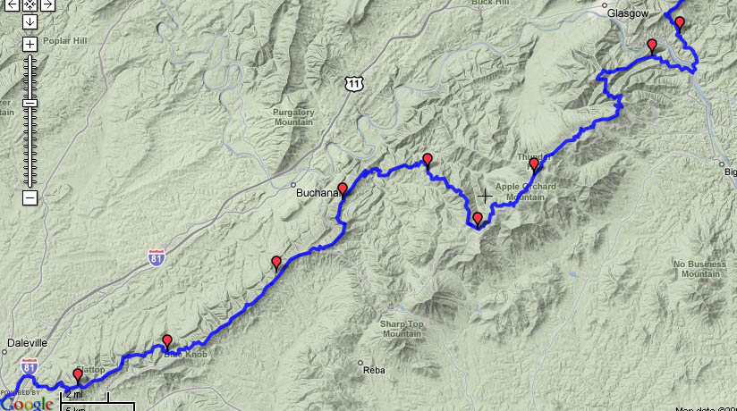
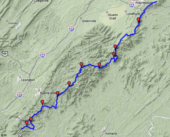
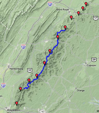
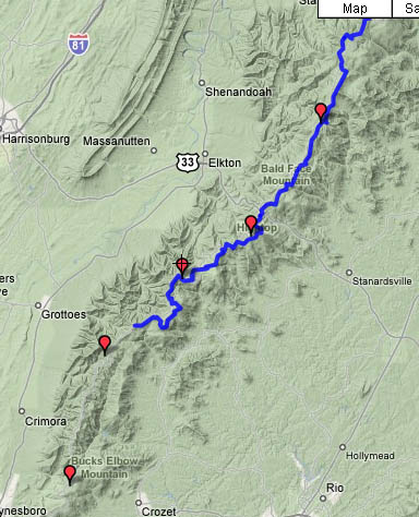
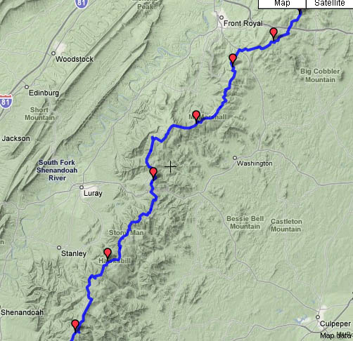
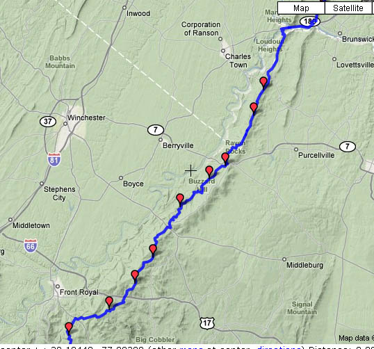
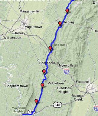
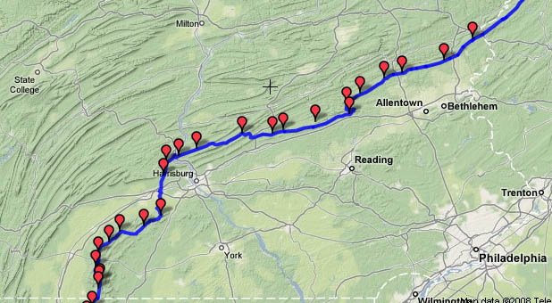
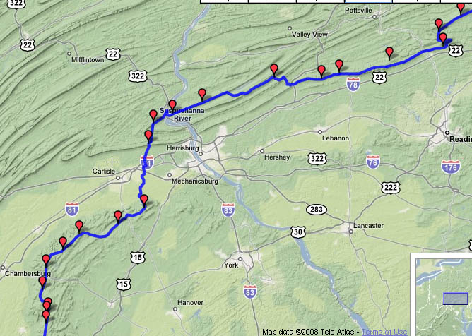
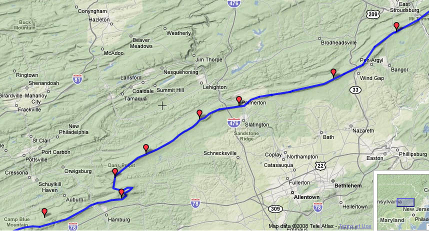
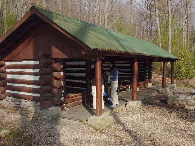
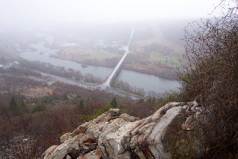
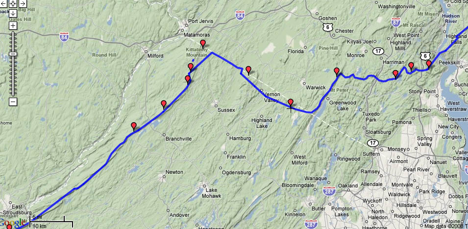
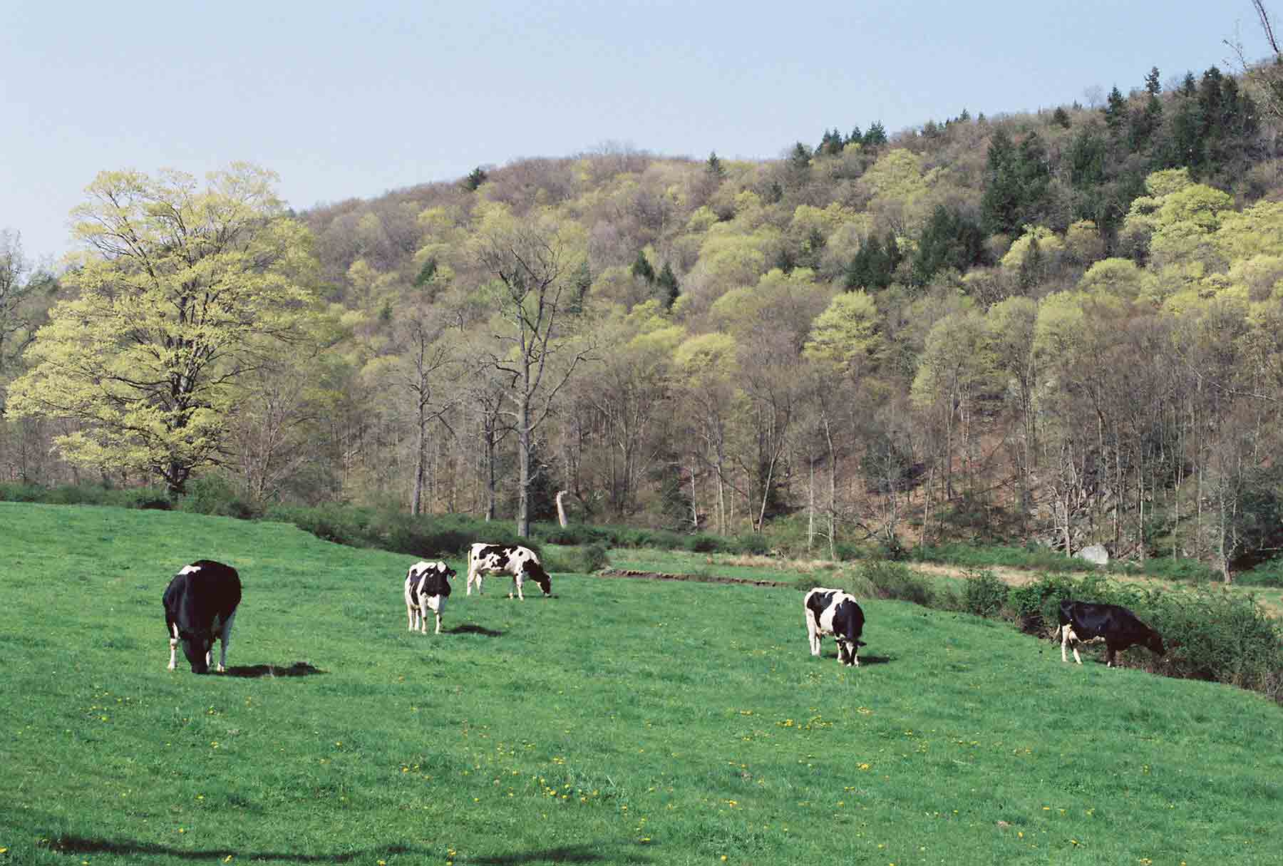