 Dick’s Creek Gap to
 Fontana
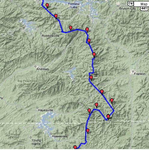
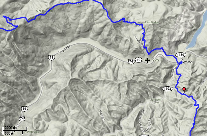
Route map with terrain features | Detail of the descent into Nantahala gorge | Elevation
profile of entire trip
Tues 3/28 Dicks Creek
 Our initial intention in planning this
hike was to leave a car at Fontana Dam, get a shuttle ride to Dicks Creek Gap,
and backpack north back to our car. We
hoped to do the hike in seven days, which was the exact amount of time I had
available during spring break. As the
time of the trip approached, we decided to day-hike the section instead, for
two reasons – both related to the short time frame. One was that Tatiana had developed a wrist
injury in a minor fall, and we were concerned about her ability to complete the
hike. The other was that the forecast
called for cold temperatures and snow, and we were concerned that a large
amount of snow could slow our progress to the point that we would not complete
the hike in time. So we planned a
day-hike itinerary with more miles per day, and spent a couple of days at Francis Marion National Forest and Fort Sumpter on the way down. The first day of hiking started on a cool,
rainy morning. We had slept in our car
at a National Forest campground nearby, deciding not to set up the tent because
it was dark and raining when we arrived.
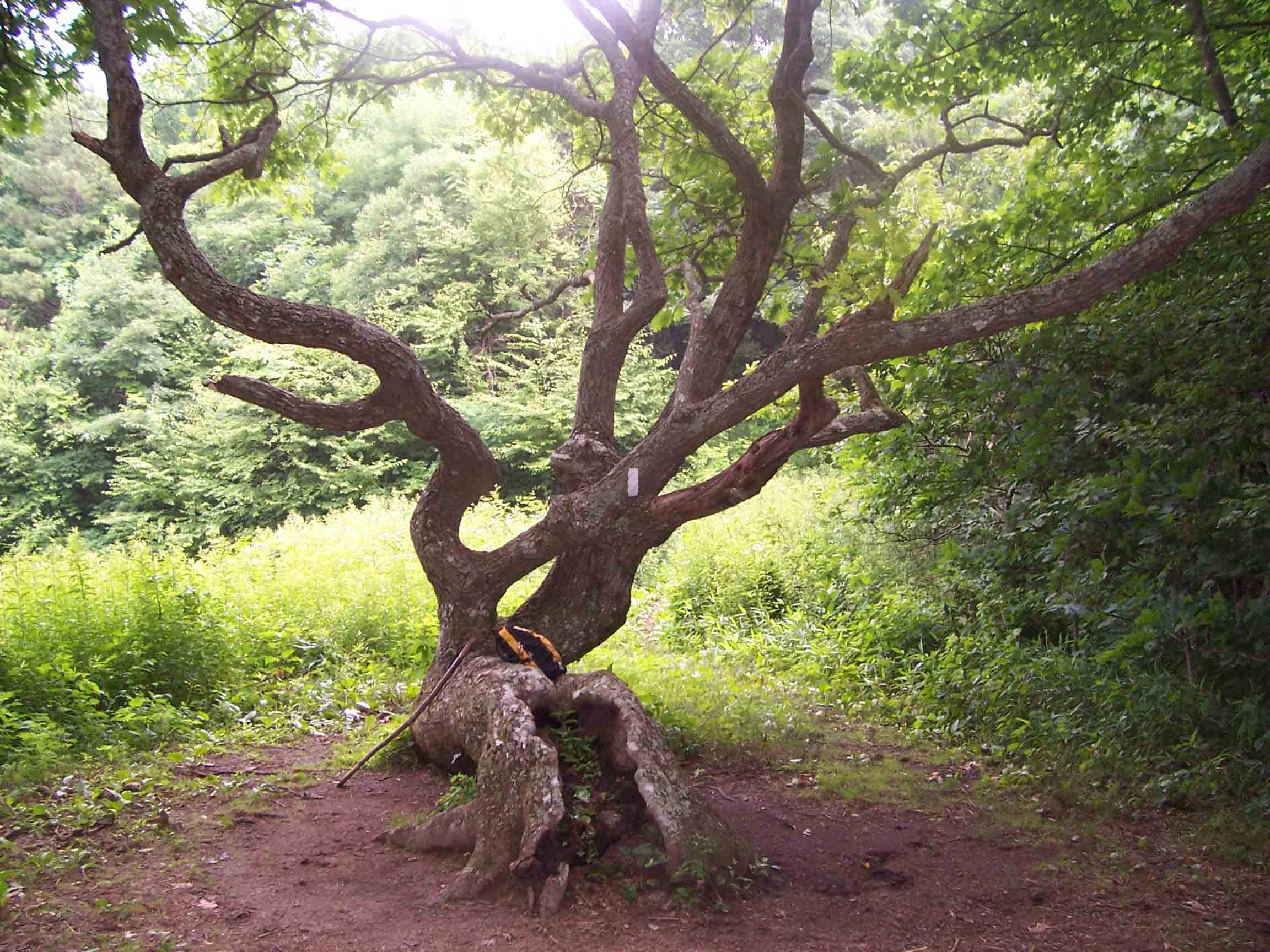
The initial climb was unrelenting, it seemed – not rocky, but steadily
up. I passed the famous twisted oak tree at Bly Gap on the
state line, then continued up to a
Our initial intention in planning this
hike was to leave a car at Fontana Dam, get a shuttle ride to Dicks Creek Gap,
and backpack north back to our car. We
hoped to do the hike in seven days, which was the exact amount of time I had
available during spring break. As the
time of the trip approached, we decided to day-hike the section instead, for
two reasons – both related to the short time frame. One was that Tatiana had developed a wrist
injury in a minor fall, and we were concerned about her ability to complete the
hike. The other was that the forecast
called for cold temperatures and snow, and we were concerned that a large
amount of snow could slow our progress to the point that we would not complete
the hike in time. So we planned a
day-hike itinerary with more miles per day, and spent a couple of days at Francis Marion National Forest and Fort Sumpter on the way down. The first day of hiking started on a cool,
rainy morning. We had slept in our car
at a National Forest campground nearby, deciding not to set up the tent because
it was dark and raining when we arrived.
The initial climb was unrelenting, it seemed – not rocky, but steadily
up. I passed the famous twisted oak tree at Bly Gap on the
state line, then continued up to a
Wed 3/29 Beech Gap à Winding Stair Gap 19.1 Elevation
profile

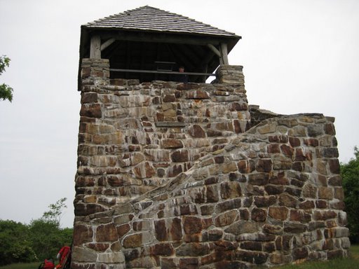
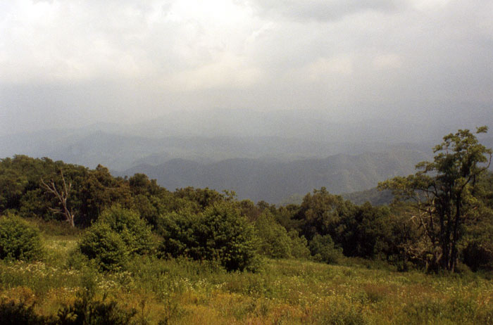
Temperatures were very cold overnight, a trend that would continue throughout the trip. There was only one other camper at the campground, so we felt quite isolated. In the morning, Tatiana dropped me off at Winding Stair Gap, on US 64, then drove back to the spot where she parked yesterday and hiked south from Beech Gap. From Beech Gap, the trail climbed and then soon descended again to Wallace Gap, where another road leads to 64. The temperatures remained cold, and ice crystals could be seen in the mud where it had frozen overnight. I had a hard time regulating temperature, repeatedly taking off layers while climbing and then putting them back on when the trail leveled off. The highlight of the day was the view from Albert Mountain, where a fire tower rises above the trees for an outstanding view. Descending the mountain was a bit tricky, as the trail passes over an uncharacteristically rocky and steep section. In the next gap I came upon a clearing where people were serving pancakes and coffee for hikers. They had driven in on a rough gravel road with an RV, and were planning to hang out for a few weeks while the main pulse of thru-hikers came through. Soon after I met up with Tatiana, and we returned along the ridge to Beech Gap and down to the campground.
Thurs 3/30 Winding
Stair à Nantahala
River

The following morning, Tatiana again dropped me off at
Winding Stair Gap, and I headed north. I
got an early start, knowing it would be a long hike. Tatiana had to drive east to
Fri 3/31 Nantahala River

 Starting from the NOC, today I attempted
one of the longest sustained climbs on the trail – 3000 feet of elevation gain from the river to Cheoha Bald. Before starting the hike, we had a memorable
breakfast at the restaurant
overlooking the river (see pic at right).
It had rained over night, and as I ascended I soon realized that cold
temperatures had turned the precipitation to snow further up the mountain. I could see the snow line as I approached it,
and as I hiked further up I found myself striding through several inches of
white powder. I stopped and took a break
at Sassafras
Gap Shelter, where the blanket of snow created a scenic effect to the
environs. I did not pause long on the
top of the bald, because the view was completely blocked by clouds – and the
weather was cold enough that stopping was dangerous. As I followed the trail north, it felt like I
should be skiing instead of hiking – the snow conditions and temperatures
seemed appropriate for gliding through the woods with boards on my feet. The section ended at Stecoah Gap, which at an
elevation of 3165’ was covered in snow.
As we descended toward
Starting from the NOC, today I attempted
one of the longest sustained climbs on the trail – 3000 feet of elevation gain from the river to Cheoha Bald. Before starting the hike, we had a memorable
breakfast at the restaurant
overlooking the river (see pic at right).
It had rained over night, and as I ascended I soon realized that cold
temperatures had turned the precipitation to snow further up the mountain. I could see the snow line as I approached it,
and as I hiked further up I found myself striding through several inches of
white powder. I stopped and took a break
at Sassafras
Gap Shelter, where the blanket of snow created a scenic effect to the
environs. I did not pause long on the
top of the bald, because the view was completely blocked by clouds – and the
weather was cold enough that stopping was dangerous. As I followed the trail north, it felt like I
should be skiing instead of hiking – the snow conditions and temperatures
seemed appropriate for gliding through the woods with boards on my feet. The section ended at Stecoah Gap, which at an
elevation of 3165’ was covered in snow.
As we descended toward
Sat 4/1 Stecoah Gap à Fontana

 The next day I
started in again at Stecoah Gap.
Conditions were similar to the previous day – I think more snow might
have fallen over night. When I took a
break at the Cable
Gap Shelter my hands were so cold that I had to sit on them for a bit in
order to regain circulation – and this in spite of wearing gloves – I was not
unprepared! The trail dropped down
steeply, out of the snowy world, to cross a road at the edge of the developed
area near Fontana Dam, then
continued on a bumpy ridge for a mile to the dam itself – where we ended our
section. I gazed longingly at the high
ridge of the
The next day I
started in again at Stecoah Gap.
Conditions were similar to the previous day – I think more snow might
have fallen over night. When I took a
break at the Cable
Gap Shelter my hands were so cold that I had to sit on them for a bit in
order to regain circulation – and this in spite of wearing gloves – I was not
unprepared! The trail dropped down
steeply, out of the snowy world, to cross a road at the edge of the developed
area near Fontana Dam, then
continued on a bumpy ridge for a mile to the dam itself – where we ended our
section. I gazed longingly at the high
ridge of the